Gondang geodata
Gondang (Central Java) is a seat of a fourth-order administrative division; located in Indonesia in Asia/Jakarta (GMT+7) time zone. In our database, there are 407 cities with bigger population. Compared to other cities in Indonesia, 65.2% of cities are located further ↓South; 61.5% of cities are located further →East and 55.6% of cities have higher elevation than Gondang. Note1


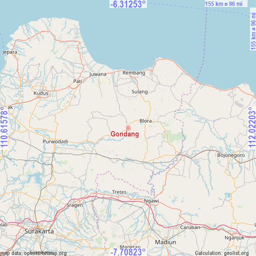
Gondang GPS coordinates[2]
7° 0' 39.24" South, 111° 19' 8.04" East
| Map corner | latitude | longitude |
|---|---|---|
| Upper-left | -6.31253°, | 110.61578° |
| Center: | -7.0109°, | 111.3189° |
| Lower-right: | -7.70823°, | 112.02203° |
| Map W x H: | 155.2×155.2 km | = 96.4×96.4mi |
| max Lat: | 5.88969° ⇑34.8% North |
| Gondang: | -7.0109° |
| min Lat: | ⇓65.2% South -10.934° |
| min Long | Gondang | max Long |
| 95.1345° | 111.3189° | 140.9419° |
| W 38.5%⇐ | ⇒61.5% E |
Elevation
Elevation of Gondang is 81 m = 266 ft, and this is 148.7 m = 488 ft below average elevation for this country.
| Max E: |
3185 m = 10449 ft | 55.6% |
| Avg. | 229.7 m = 754 ft | |
| Gondang | 81 m = 266 ft | |
Min E: |
-1 m = -3 ft | 44.4% |
See also: Indonesia elevation on elevation.city.
Geographical zone
Gondang is located in South Torrid zone (between Equator and Tropic of Capricorn). Distance of Equator is 779.5 km =484.4 mi to North.| Distance of | km | miles | from Gondang |
|---|---|---|---|
| Equator | 779.5 | 484.4 | to North |
| Tropic Capricorn | 1826.4 | 1134.9 | to South |
| Antarctic Circle | 6621.6 | 4114.5 | to South |
| South Pole | 9227.5 | 5733.7 | to South |


Nearby cities:
15 places around Gondang: (largest is in red/bold)
• Berbak
1.5 km =0.9 mi,  336°
336°
• Bradag
3.3 km =2.1 mi,  306°
306°
• Gapuk
2.9 km =1.8 mi,  146°
146°
• Gotputuk
2.8 km =1.7 mi,  329°
329°
• Karangtalun
3.7 km =2.3 mi,  106°
106°
• Karangtengah
3.2 km =2 mi,  183°
183°
• Ketanggi
0.6 km =0.4 mi,  209°
209°
• Ngawen
1.1 km =0.7 mi,  322°
322°
• Pecaren
2.1 km =1.3 mi,  281°
281°
• Pruntusan
3.2 km =2 mi,  76°
76°
• Pudak
2.6 km =1.6 mi,  17°
17°
• Punggursugih
0.9 km =0.6 mi,  252°
252°
• Sambongrejo
3.6 km =2.2 mi,  355°
355°
• Talok
2.6 km =1.6 mi,  217°
217°
• Trembulrejo
1.7 km =1.1 mi,  232°
232°
Sources, notices
• [Note1] Compared only with cities in Indonesia existing in our database
• [Src1] Map data: © OpenStreetMap contributors (CC-BY-SA)
• [Src2] Other city data from geonames.org with taken over terms of usage.
• [Src3] Geographical zone / Annual Mean Temperature by Robert A. Rohde @ Wikipedia
