Jawakisa geodata
Jawakisa (East Nusa Tenggara) is a seat of a fourth-order administrative division; located in Indonesia in Asia/Makassar (GMT+8) time zone. In our database, there are 407 cities with bigger population. Compared to other cities in Indonesia, 88.4% of cities are located further ↑North; 86.2% of cities are located further ←West and 82.1% of cities have lower elevation than Jawakisa. Note1


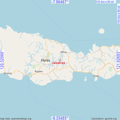
Jawakisa GPS coordinates[2]
8° 39' 37.44" South, 121° 13' 25.68" East
| Map corner | latitude | longitude |
|---|---|---|
| Upper-left | -7.96467°, | 120.52068° |
| Center: | -8.6604°, | 121.2238° |
| Lower-right: | -9.35485°, | 121.92693° |
| Map W x H: | 154.6×154.6 km | = 96.1×96.1mi |
| max Lat: | 5.88969° ⇑88.4% North |
| Jawakisa: | -8.6604° |
| min Lat: | ⇓11.6% South -10.934° |
| min Long | Jawakisa | max Long |
| 95.1345° | 121.2238° | 140.9419° |
| W 86.2%⇐ | ⇒13.8% E |
Elevation
Elevation of Jawakisa is 465 m = 1526 ft, and this is 235.3 m = 772 ft above average elevation for this country.
| Max E: |
3185 m = 10449 ft | 17.9% |
| Jawakisa | 465 m 1526 ft | |
| Avg. | 229.7 m = 754 ft | |
Min E: |
-1 m = -3 ft | 82.1% |
See also: Indonesia elevation on elevation.city.
Geographical zone
Jawakisa is located in South Torrid zone (between Equator and Tropic of Capricorn). Distance of Equator is 962.9 km =598.3 mi to North.| Distance of | km | miles | from Jawakisa |
|---|---|---|---|
| Equator | 962.9 | 598.3 | to North |
| Tropic Capricorn | 1643 | 1020.9 | to South |
| Antarctic Circle | 6438.2 | 4000.5 | to South |
| South Pole | 9044.1 | 5619.7 | to South |


Nearby cities:
15 places around Jawakisa: (largest is in red/bold)
• Baobe
8.8 km =5.5 mi,  7°
7°
• Boanio
11.2 km =7 mi,  76°
76°
• Doma
11.7 km =7.3 mi,  103°
103°
• Gero
6.2 km =3.9 mi,  219°
219°
• Jawagae
12.1 km =7.5 mi,  173°
173°
• Jawatiwa
8.2 km =5.1 mi,  129°
129°
• Malapaubhara
11 km =6.8 mi,  277°
277°
• Malawona
5.3 km =3.3 mi, 8°
• Mbay
12.2 km =7.6 mi,  25°
25°
• Pamakoe
11.4 km =7.1 mi, 165°
• Rega
12.1 km =7.5 mi,  187°
187°
• Tibakisa
11.8 km =7.3 mi,  204°
204°
• Tibakisa
12.5 km =7.8 mi, 134°
• Uluwolo
12 km =7.5 mi,  37°
37°
• Watugase
8.9 km =5.5 mi,  208°
208°
Sources, notices
• [Note1] Compared only with cities in Indonesia existing in our database
• [Src1] Map data: © OpenStreetMap contributors (CC-BY-SA)
• [Src2] Other city data from geonames.org with taken over terms of usage.
• [Src3] Geographical zone / Annual Mean Temperature by Robert A. Rohde @ Wikipedia
