Malapaubhara geodata
Malapaubhara (East Nusa Tenggara) is a seat of a fourth-order administrative division; located in Indonesia in Asia/Makassar (GMT+8) time zone. In our database, there are 407 cities with bigger population. Compared to other cities in Indonesia, 88.1% of cities are located further ↑North; 85.9% of cities are located further ←West and 77.8% of cities have lower elevation than Malapaubhara. Note1


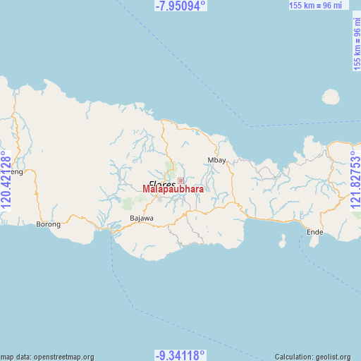
Malapaubhara GPS coordinates[2]
8° 38' 48.12" South, 121° 7' 27.84" East
| Map corner | latitude | longitude |
|---|---|---|
| Upper-left | -7.95094°, | 120.42128° |
| Center: | -8.6467°, | 121.1244° |
| Lower-right: | -9.34118°, | 121.82753° |
| Map W x H: | 154.6×154.6 km | = 96.1×96.1mi |
| max Lat: | 5.88969° ⇑88.1% North |
| Malapaubhara: | -8.6467° |
| min Lat: | ⇓11.9% South -10.934° |
| min Long | Malapaubhara | max Long |
| 95.1345° | 121.1244° | 140.9419° |
| W 85.9%⇐ | ⇒14.1% E |
Elevation
Elevation of Malapaubhara is 394 m = 1293 ft, and this is 164.3 m = 539 ft above average elevation for this country.
| Max E: |
3185 m = 10449 ft | 22.2% |
| Malapaubhara | 394 m 1293 ft | |
| Avg. | 229.7 m = 754 ft | |
Min E: |
-1 m = -3 ft | 77.8% |
See also: Indonesia elevation on elevation.city.
Geographical zone
Malapaubhara is located in South Torrid zone (between Equator and Tropic of Capricorn). Distance of Equator is 961.4 km =597.4 mi to North.| Distance of | km | miles | from Malapaubhara |
|---|---|---|---|
| Equator | 961.4 | 597.4 | to North |
| Tropic Capricorn | 1644.5 | 1021.8 | to South |
| Antarctic Circle | 6439.8 | 4001.5 | to South |
| South Pole | 9045.6 | 5620.7 | to South |


Nearby cities:
15 places around Malapaubhara: (largest is in red/bold)
• Anafolo
12.1 km =7.5 mi,  227°
227°
• Baobe
14 km =8.7 mi,  59°
59°
• Boawae
13.9 km =8.6 mi,  159°
159°
• Gero
9.5 km =5.9 mi,  132°
132°
• Jawakisa
11 km =6.8 mi,  97°
97°
• Loa
11.9 km =7.4 mi, 225°
• Malabai
10 km =6.2 mi,  17°
17°
• Malawona
12.3 km =7.6 mi,  72°
72°
• Masu
11.8 km =7.3 mi, 232°
• Piga
11.3 km =7 mi, 228°
• Soa
11.3 km =7 mi,  239°
239°
• Tibakisa
13.7 km =8.5 mi,  154°
154°
• Waepana
10.8 km =6.7 mi, 241°
• Watugase
11.5 km =7.1 mi,  144°
144°
• Zepe
13.9 km =8.6 mi,  194°
194°
Sources, notices
• [Note1] Compared only with cities in Indonesia existing in our database
• [Src1] Map data: © OpenStreetMap contributors (CC-BY-SA)
• [Src2] Other city data from geonames.org with taken over terms of usage.
• [Src3] Geographical zone / Annual Mean Temperature by Robert A. Rohde @ Wikipedia
