Doma geodata
Doma (East Nusa Tenggara) is a seat of a fourth-order administrative division; located in Indonesia in Asia/Makassar (GMT+8) time zone. In our database, there are 407 cities with bigger population. Compared to other cities in Indonesia, 88.9% of cities are located further ↑North; 86.5% of cities are located further ←West and 79.7% of cities have lower elevation than Doma. Note1


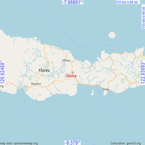
Doma GPS coordinates[2]
8° 41' 4.56" South, 121° 19' 40.08" East
| Map corner | latitude | longitude |
|---|---|---|
| Upper-left | -7.98891°, | 120.62468° |
| Center: | -8.6846°, | 121.3278° |
| Lower-right: | -9.379°, | 122.03093° |
| Map W x H: | 154.6×154.6 km | = 96.1×96.1mi |
| max Lat: | 5.88969° ⇑88.9% North |
| Doma: | -8.6846° |
| min Lat: | ⇓11.1% South -10.934° |
| min Long | Doma | max Long |
| 95.1345° | 121.3278° | 140.9419° |
| W 86.5%⇐ | ⇒13.5% E |
Elevation
Elevation of Doma is 427 m = 1401 ft, and this is 197.3 m = 647 ft above average elevation for this country.
| Max E: |
3185 m = 10449 ft | 20.3% |
| Doma | 427 m 1401 ft | |
| Avg. | 229.7 m = 754 ft | |
Min E: |
-1 m = -3 ft | 79.7% |
See also: Indonesia elevation on elevation.city.
Geographical zone
Doma is located in South Torrid zone (between Equator and Tropic of Capricorn). Distance of Equator is 965.6 km =600 mi to North.| Distance of | km | miles | from Doma |
|---|---|---|---|
| Equator | 965.6 | 600 | to North |
| Tropic Capricorn | 1640.3 | 1019.2 | to South |
| Antarctic Circle | 6435.5 | 3998.8 | to South |
| South Pole | 9041.4 | 5618.1 | to South |


Nearby cities:
15 places around Doma: (largest is in red/bold)
• Aegela
5.4 km =3.4 mi,  168°
168°
• Bhokadoke
13.2 km =8.2 mi,  187°
187°
• Boanio
5.3 km =3.3 mi,  354°
354°
• Jawakisa
11.7 km =7.3 mi,  283°
283°
• Jawatiwa
5.7 km =3.5 mi,  243°
243°
• Kuekobo
7.9 km =4.9 mi,  115°
115°
• Lena
9 km =5.6 mi,  199°
199°
• Malawona
13.3 km =8.3 mi,  306°
306°
• Nangaroro
13.4 km =8.3 mi,  148°
148°
• Oja
11.5 km =7.1 mi,  94°
94°
• Pamakoe
11.9 km =7.4 mi,  225°
225°
• Puukau
12 km =7.5 mi,  111°
111°
• Tibakisa
6.6 km =4.1 mi, 202°
• Uluwolo
12.8 km =8 mi,  341°
341°
• Watuapi
13 km =8.1 mi,  51°
51°
Sources, notices
• [Note1] Compared only with cities in Indonesia existing in our database
• [Src1] Map data: © OpenStreetMap contributors (CC-BY-SA)
• [Src2] Other city data from geonames.org with taken over terms of usage.
• [Src3] Geographical zone / Annual Mean Temperature by Robert A. Rohde @ Wikipedia
