Woloara geodata
Woloara (East Nusa Tenggara) is a seat of a fourth-order administrative division; located in Indonesia in Asia/Makassar (GMT+8) time zone. In our database, there are 407 cities with bigger population. Compared to other cities in Indonesia, 90.4% of cities are located further ↑North; 88% of cities are located further ←West and 86.1% of cities have lower elevation than Woloara. Note1


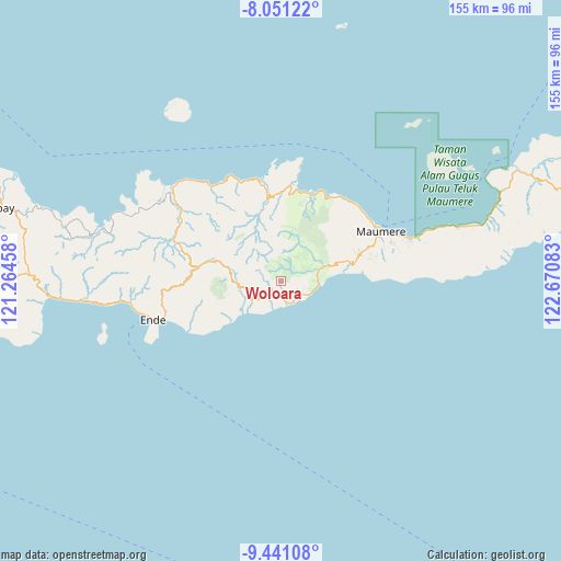
Woloara GPS coordinates[2]
8° 44' 48.48" South, 121° 58' 3.72" East
| Map corner | latitude | longitude |
|---|---|---|
| Upper-left | -8.05122°, | 121.26458° |
| Center: | -8.7468°, | 121.9677° |
| Lower-right: | -9.44108°, | 122.67083° |
| Map W x H: | 154.5×154.5 km | = 96×96mi |
| max Lat: | 5.88969° ⇑90.4% North |
| Woloara: | -8.7468° |
| min Lat: | ⇓9.6% South -10.934° |
| min Long | Woloara | max Long |
| 95.1345° | 121.9677° | 140.9419° |
| W 88%⇐ | ⇒12% E |
Elevation
Elevation of Woloara is 538 m = 1765 ft, and this is 308.3 m = 1011 ft above average elevation for this country.
| Max E: |
3185 m = 10449 ft | 13.9% |
| Woloara | 538 m 1765 ft | |
| Avg. | 229.7 m = 754 ft | |
Min E: |
-1 m = -3 ft | 86.1% |
See also: Indonesia elevation on elevation.city.
Geographical zone
Woloara is located in South Torrid zone (between Equator and Tropic of Capricorn). Distance of Equator is 972.6 km =604.3 mi to North.| Distance of | km | miles | from Woloara |
|---|---|---|---|
| Equator | 972.6 | 604.3 | to North |
| Tropic Capricorn | 1633.4 | 1014.9 | to South |
| Antarctic Circle | 6428.6 | 3994.5 | to South |
| South Pole | 9034.5 | 5613.8 | to South |


Nearby cities:
15 places around Woloara: (largest is in red/bold)
• Aemalu
3.3 km =2.1 mi,  230°
230°
• Aeteke
6 km =3.7 mi,  169°
169°
• Aipetu
5.5 km =3.4 mi, 169°
• Detupia
6 km =3.7 mi,  70°
70°
• Jitapanda
3.5 km =2.2 mi,  199°
199°
• Liabeke
5.6 km =3.5 mi, 233°
• Masebewa
6.4 km =4 mi, 70°
• Mauloo
8.4 km =5.2 mi,  118°
118°
• Ratenggoji
8.9 km =5.5 mi,  320°
320°
• Wolobela
1.8 km =1.1 mi,  305°
305°
• Wolofeo
3.7 km =2.3 mi,  40°
40°
• Wololele A
5.9 km =3.7 mi,  259°
259°
• Wololele B
8.4 km =5.2 mi, 258°
• Wolowiro
6.3 km =3.9 mi,  126°
126°
• Wonda
6 km =3.7 mi,  214°
214°
Sources, notices
• [Note1] Compared only with cities in Indonesia existing in our database
• [Src1] Map data: © OpenStreetMap contributors (CC-BY-SA)
• [Src2] Other city data from geonames.org with taken over terms of usage.
• [Src3] Geographical zone / Annual Mean Temperature by Robert A. Rohde @ Wikipedia
