Wololele B geodata
Wololele B (East Nusa Tenggara) is a seat of a fourth-order administrative division; located in Indonesia in Asia/Makassar (GMT+8) time zone. In our database, there are 407 cities with bigger population. Compared to other cities in Indonesia, 90.7% of cities are located further ↑North; 87.7% of cities are located further ←West and 76.9% of cities have lower elevation than Wololele B. Note1


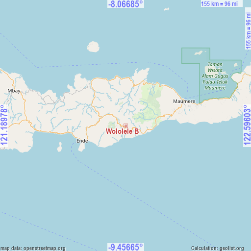
Wololele B GPS coordinates[2]
8° 45' 44.64" South, 121° 53' 34.44" East
| Map corner | latitude | longitude |
|---|---|---|
| Upper-left | -8.06685°, | 121.18978° |
| Center: | -8.7624°, | 121.8929° |
| Lower-right: | -9.45665°, | 122.59603° |
| Map W x H: | 154.5×154.5 km | = 96×96mi |
| max Lat: | 5.88969° ⇑90.7% North |
| Wololele B: | -8.7624° |
| min Lat: | ⇓9.3% South -10.934° |
| min Long | Wololele B | max Long |
| 95.1345° | 121.8929° | 140.9419° |
| W 87.7%⇐ | ⇒12.3% E |
Elevation
Elevation of Wololele B is 383 m = 1257 ft, and this is 153.3 m = 503 ft above average elevation for this country.
| Max E: |
3185 m = 10449 ft | 23.1% |
| Wololele B | 383 m 1257 ft | |
| Avg. | 229.7 m = 754 ft | |
Min E: |
-1 m = -3 ft | 76.9% |
See also: Indonesia elevation on elevation.city.
Geographical zone
Wololele B is located in South Torrid zone (between Equator and Tropic of Capricorn). Distance of Equator is 974.3 km =605.4 mi to North.| Distance of | km | miles | from Wololele B |
|---|---|---|---|
| Equator | 974.3 | 605.4 | to North |
| Tropic Capricorn | 1631.6 | 1013.8 | to South |
| Antarctic Circle | 6426.9 | 3993.5 | to South |
| South Pole | 9032.8 | 5612.7 | to South |


Nearby cities:
15 places around Wololele B: (largest is in red/bold)
• Aemalu
5.6 km =3.5 mi,  93°
93°
• Aeteke
10.2 km =6.3 mi,  114°
114°
• Aipetu
9.9 km =6.2 mi, 111°
• Baolokan
1.5 km =0.9 mi,  197°
197°
• Jitapanda
7.2 km =4.5 mi,  102°
102°
• Koanara
4.7 km =2.9 mi,  289°
289°
• Liabeke
4 km =2.5 mi, 112°
• Maubasa
8.3 km =5.2 mi,  148°
148°
• Nduaria
9 km =5.6 mi,  308°
308°
• Ratenggoji
9 km =5.6 mi,  16°
16°
• Woloara
8.4 km =5.2 mi,  78°
78°
• Wolobela
7.3 km =4.5 mi,  67°
67°
• Wololele A
2.5 km =1.6 mi, 75°
• Wolowaru
2.5 km =1.6 mi, 197°
• Wonda
5.8 km =3.6 mi,  123°
123°
Sources, notices
• [Note1] Compared only with cities in Indonesia existing in our database
• [Src1] Map data: © OpenStreetMap contributors (CC-BY-SA)
• [Src2] Other city data from geonames.org with taken over terms of usage.
• [Src3] Geographical zone / Annual Mean Temperature by Robert A. Rohde @ Wikipedia
