Liabeke geodata
Liabeke (East Nusa Tenggara) is a seat of a fourth-order administrative division; located in Indonesia in Asia/Makassar (GMT+8) time zone. In our database, there are 407 cities with bigger population. Compared to other cities in Indonesia, 90.9% of cities are located further ↑North; 87.8% of cities are located further ←West and 82.1% of cities have lower elevation than Liabeke. Note1


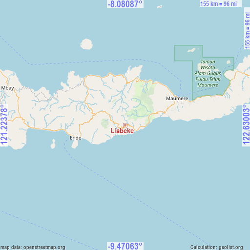
Liabeke GPS coordinates[2]
8° 46' 35.04" South, 121° 55' 36.84" East
| Map corner | latitude | longitude |
|---|---|---|
| Upper-left | -8.08087°, | 121.22378° |
| Center: | -8.7764°, | 121.9269° |
| Lower-right: | -9.47063°, | 122.63003° |
| Map W x H: | 154.5×154.5 km | = 96×96mi |
| max Lat: | 5.88969° ⇑90.9% North |
| Liabeke: | -8.7764° |
| min Lat: | ⇓9.1% South -10.934° |
| min Long | Liabeke | max Long |
| 95.1345° | 121.9269° | 140.9419° |
| W 87.8%⇐ | ⇒12.2% E |
Elevation
Elevation of Liabeke is 465 m = 1526 ft, and this is 235.3 m = 772 ft above average elevation for this country.
| Max E: |
3185 m = 10449 ft | 17.9% |
| Liabeke | 465 m 1526 ft | |
| Avg. | 229.7 m = 754 ft | |
Min E: |
-1 m = -3 ft | 82.1% |
See also: Indonesia elevation on elevation.city.
Geographical zone
Liabeke is located in South Torrid zone (between Equator and Tropic of Capricorn). Distance of Equator is 975.8 km =606.3 mi to North.| Distance of | km | miles | from Liabeke |
|---|---|---|---|
| Equator | 975.8 | 606.3 | to North |
| Tropic Capricorn | 1630.1 | 1012.9 | to South |
| Antarctic Circle | 6425.3 | 3992.5 | to South |
| South Pole | 9031.2 | 5611.7 | to South |


Nearby cities:
15 places around Liabeke: (largest is in red/bold)
• Aemalu
2.2 km =1.4 mi,  57°
57°
• Aeteke
6.2 km =3.9 mi,  115°
115°
• Aipetu
5.8 km =3.6 mi,  111°
111°
• Baolokan
4.2 km =2.6 mi,  271°
271°
• Jitapanda
3.3 km =2.1 mi,  90°
90°
• Koanara
8.8 km =5.5 mi,  290°
290°
• Maubasa
5.6 km =3.5 mi,  173°
173°
• Woloara
5.6 km =3.5 mi,  53°
53°
• Wolobela
5.3 km =3.3 mi,  34°
34°
• Wolofeo
9.2 km =5.7 mi, 48°
• Wololele A
2.5 km =1.6 mi,  329°
329°
• Wololele B
4 km =2.5 mi, 292°
• Wolowaru
4.6 km =2.9 mi,  260°
260°
• Wolowiro
9.5 km =5.9 mi, 92°
• Wonda
2 km =1.2 mi,  145°
145°
Sources, notices
• [Note1] Compared only with cities in Indonesia existing in our database
• [Src1] Map data: © OpenStreetMap contributors (CC-BY-SA)
• [Src2] Other city data from geonames.org with taken over terms of usage.
• [Src3] Geographical zone / Annual Mean Temperature by Robert A. Rohde @ Wikipedia
