Hokor geodata
Hokor (East Nusa Tenggara) is a seat of a fourth-order administrative division; located in Indonesia in Asia/Makassar (GMT+8) time zone. In our database, there are 407 cities with bigger population. Compared to other cities in Indonesia, 90.1% of cities are located further ↑North; 88.6% of cities are located further ←West and 77% of cities have lower elevation than Hokor. Note1


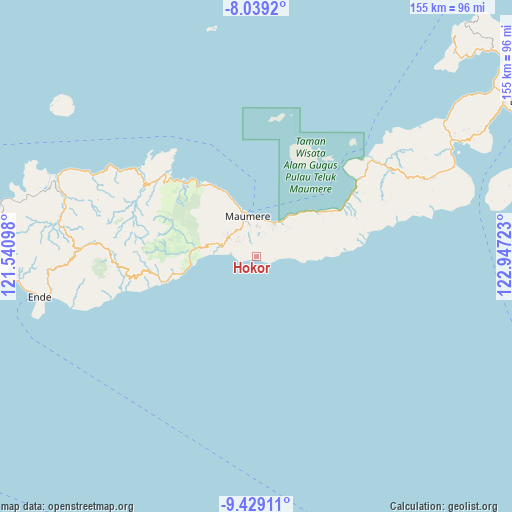
Hokor GPS coordinates[2]
8° 44' 5.28" South, 122° 14' 38.76" East
| Map corner | latitude | longitude |
|---|---|---|
| Upper-left | -8.0392°, | 121.54098° |
| Center: | -8.7348°, | 122.2441° |
| Lower-right: | -9.42911°, | 122.94723° |
| Map W x H: | 154.5×154.5 km | = 96×96mi |
| max Lat: | 5.88969° ⇑90.1% North |
| Hokor: | -8.7348° |
| min Lat: | ⇓9.9% South -10.934° |
| min Long | Hokor | max Long |
| 95.1345° | 122.2441° | 140.9419° |
| W 88.6%⇐ | ⇒11.4% E |
Elevation
Elevation of Hokor is 384 m = 1260 ft, and this is 154.3 m = 506 ft above average elevation for this country.
| Max E: |
3185 m = 10449 ft | 23% |
| Hokor | 384 m 1260 ft | |
| Avg. | 229.7 m = 754 ft | |
Min E: |
-1 m = -3 ft | 77% |
See also: Indonesia elevation on elevation.city.
Geographical zone
Hokor is located in South Torrid zone (between Equator and Tropic of Capricorn). Distance of Equator is 971.2 km =603.5 mi to North.| Distance of | km | miles | from Hokor |
|---|---|---|---|
| Equator | 971.2 | 603.5 | to North |
| Tropic Capricorn | 1634.7 | 1015.8 | to South |
| Antarctic Circle | 6430 | 3995.4 | to South |
| South Pole | 9035.8 | 5614.6 | to South |


Nearby cities:
15 places around Hokor: (largest is in red/bold)
• Baluk
6.7 km =4.2 mi,  97°
97°
• Baobatun
6.7 km =4.2 mi,  37°
37°
• Bei
4.8 km =3 mi, 37°
• Bola
5.7 km =3.5 mi, 97°
• Gehaklau
6.7 km =4.2 mi,  311°
311°
• Habingkloang
4.1 km =2.5 mi,  4°
4°
• Halat
7 km =4.3 mi,  324°
324°
• Ili
7.1 km =4.4 mi,  19°
19°
• Nele
7.2 km =4.5 mi,  333°
333°
• Ojan
4 km =2.5 mi,  27°
27°
• Puho
6.1 km =3.8 mi,  292°
292°
• Sikka
5.5 km =3.4 mi,  252°
252°
• Tadabliro
6.4 km =4 mi, 331°
• Taranggatar
3 km =1.9 mi, 97°
• Wolokoli
4.1 km =2.5 mi,  79°
79°
Sources, notices
• [Note1] Compared only with cities in Indonesia existing in our database
• [Src1] Map data: © OpenStreetMap contributors (CC-BY-SA)
• [Src2] Other city data from geonames.org with taken over terms of usage.
• [Src3] Geographical zone / Annual Mean Temperature by Robert A. Rohde @ Wikipedia
