Wolokoli geodata
Wolokoli (East Nusa Tenggara) is a seat of a fourth-order administrative division; located in Indonesia in Asia/Makassar (GMT+8) time zone. In our database, there are 407 cities with bigger population. Compared to other cities in Indonesia, 89.9% of cities are located further ↑North; 88.7% of cities are located further ←West and 69% of cities have lower elevation than Wolokoli. Note1


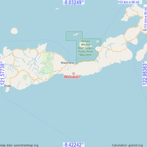
Wolokoli GPS coordinates[2]
8° 43' 41.16" South, 122° 16' 49.8" East
| Map corner | latitude | longitude |
|---|---|---|
| Upper-left | -8.03249°, | 121.57738° |
| Center: | -8.7281°, | 122.2805° |
| Lower-right: | -9.42242°, | 122.98363° |
| Map W x H: | 154.5×154.5 km | = 96×96mi |
| max Lat: | 5.88969° ⇑89.9% North |
| Wolokoli: | -8.7281° |
| min Lat: | ⇓10.1% South -10.934° |
| min Long | Wolokoli | max Long |
| 95.1345° | 122.2805° | 140.9419° |
| W 88.7%⇐ | ⇒11.3% E |
Elevation
Elevation of Wolokoli is 279 m = 915 ft, and this is 49.3 m = 162 ft above average elevation for this country.
| Max E: |
3185 m = 10449 ft | 31% |
| Wolokoli | 279 m 915 ft | |
| Avg. | 229.7 m = 754 ft | |
Min E: |
-1 m = -3 ft | 69% |
See also: Indonesia elevation on elevation.city.
Geographical zone
Wolokoli is located in South Torrid zone (between Equator and Tropic of Capricorn). Distance of Equator is 970.5 km =603 mi to North.| Distance of | km | miles | from Wolokoli |
|---|---|---|---|
| Equator | 970.5 | 603 | to North |
| Tropic Capricorn | 1635.4 | 1016.2 | to South |
| Antarctic Circle | 6430.7 | 3995.9 | to South |
| South Pole | 9036.6 | 5615.1 | to South |


Nearby cities:
15 places around Wolokoli: (largest is in red/bold)
• Baluk
3.1 km =1.9 mi,  121°
121°
• Baobatun
4.5 km =2.8 mi,  0°
0°
• Bei
3.2 km =2 mi,  340°
340°
• Bola
2.3 km =1.4 mi,  132°
132°
• Habingkloang
5 km =3.1 mi,  312°
312°
• Hokor
4.1 km =2.5 mi,  259°
259°
• Ili
6.1 km =3.8 mi, 344°
• Kloangpopot
8.1 km =5 mi,  76°
76°
• Kloangrotat
8.1 km =5 mi,  48°
48°
• Nitakloang
7.4 km =4.6 mi,  9°
9°
• Ojan
3.6 km =2.2 mi,  322°
322°
• Potet
5.9 km =3.7 mi,  31°
31°
• Taranggatar
1.5 km =0.9 mi,  222°
222°
• Watublapi
4.7 km =2.9 mi, 50°
• Watuliwung
8.3 km =5.2 mi, 339°
Sources, notices
• [Note1] Compared only with cities in Indonesia existing in our database
• [Src1] Map data: © OpenStreetMap contributors (CC-BY-SA)
• [Src2] Other city data from geonames.org with taken over terms of usage.
• [Src3] Geographical zone / Annual Mean Temperature by Robert A. Rohde @ Wikipedia
