Sere geodata
Sere (East Nusa Tenggara) is a seat of a fourth-order administrative division; located in Indonesia in Asia/Makassar (GMT+8) time zone. In our database, there are 407 cities with bigger population. Compared to other cities in Indonesia, 91.6% of cities are located further ↑North; 84.8% of cities are located further ←West and 59.8% of cities have lower elevation than Sere. Note1


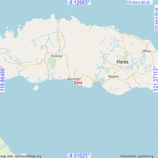
Sere GPS coordinates[2]
8° 48' 57.96" South, 120° 40' 4.8" East
| Map corner | latitude | longitude |
|---|---|---|
| Upper-left | -8.12065°, | 119.96488° |
| Center: | -8.8161°, | 120.668° |
| Lower-right: | -9.51025°, | 121.37113° |
| Map W x H: | 154.5×154.5 km | = 96×96mi |
| max Lat: | 5.88969° ⇑91.6% North |
| Sere: | -8.8161° |
| min Lat: | ⇓8.4% South -10.934° |
| min Long | Sere | max Long |
| 95.1345° | 120.668° | 140.9419° |
| W 84.8%⇐ | ⇒15.2% E |
Elevation
Elevation of Sere is 162 m = 531 ft, and this is 67.7 m = 222 ft below average elevation for this country.
| Max E: |
3185 m = 10449 ft | 40.2% |
| Avg. | 229.7 m = 754 ft | |
| Sere | 162 m = 531 ft | |
Min E: |
-1 m = -3 ft | 59.8% |
See also: Indonesia elevation on elevation.city.
Geographical zone
Sere is located in South Torrid zone (between Equator and Tropic of Capricorn). Distance of Equator is 980.3 km =609.1 mi to North.| Distance of | km | miles | from Sere |
|---|---|---|---|
| Equator | 980.3 | 609.1 | to North |
| Tropic Capricorn | 1625.7 | 1010.2 | to South |
| Antarctic Circle | 6420.9 | 3989.8 | to South |
| South Pole | 9026.8 | 5609 | to South |


Nearby cities:
15 places around Sere: (largest is in red/bold)
• Borong
6.4 km =4 mi,  273°
273°
• Gurung
5.9 km =3.7 mi,  326°
326°
• Kaca
13.8 km =8.6 mi,  310°
310°
• Kipo
4.6 km =2.9 mi,  13°
13°
• Lete
14 km =8.7 mi,  53°
53°
• Lewe
8.4 km =5.2 mi,  342°
342°
• Munde
8.1 km =5 mi,  71°
71°
• Muting
5 km =3.1 mi,  136°
136°
• Ngusu
12.2 km =7.6 mi,  4°
4°
• Pesek
13.5 km =8.4 mi, 335°
• Tado
15 km =9.3 mi, 327°
• Tuwa
10.2 km =6.3 mi,  19°
19°
• Waekolong
9.3 km =5.8 mi, 46°
• Waerana
6.4 km =4 mi, 53°
• Watuka
8.2 km =5.1 mi,  34°
34°
Sources, notices
• [Note1] Compared only with cities in Indonesia existing in our database
• [Src1] Map data: © OpenStreetMap contributors (CC-BY-SA)
• [Src2] Other city data from geonames.org with taken over terms of usage.
• [Src3] Geographical zone / Annual Mean Temperature by Robert A. Rohde @ Wikipedia
