Muting geodata
Muting (East Nusa Tenggara) is a seat of a fourth-order administrative division; located in Indonesia in Asia/Makassar (GMT+8) time zone. In our database, there are 407 cities with bigger population. Compared to other cities in Indonesia, 92.1% of cities are located further ↑North; 85% of cities are located further ←West and 66.1% of cities have higher elevation than Muting. Note1


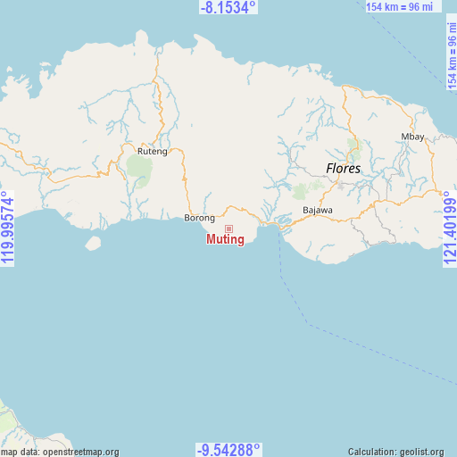
Muting GPS coordinates[2]
8° 50' 55.68" South, 120° 41' 55.896" East
| Map corner | latitude | longitude |
|---|---|---|
| Upper-left | -8.1534°, | 119.99574° |
| Center: | -8.8488°, | 120.69886° |
| Lower-right: | -9.54288°, | 121.40199° |
| Map W x H: | 154.5×154.5 km | = 96×96mi |
| max Lat: | 5.88969° ⇑92.1% North |
| Muting: | -8.8488° |
| min Lat: | ⇓7.9% South -10.934° |
| min Long | Muting | max Long |
| 95.1345° | 120.69886° | 140.9419° |
| W 85%⇐ | ⇒15% E |
Elevation
Elevation of Muting is 40 m = 131 ft, and this is 189.7 m = 622 ft below average elevation for this country.
| Max E: |
3185 m = 10449 ft | 66.1% |
| Avg. | 229.7 m = 754 ft | |
| Muting | 40 m = 131 ft | |
Min E: |
-1 m = -3 ft | 33.9% |
See also: Indonesia elevation on elevation.city.
Geographical zone
Muting is located in South Torrid zone (between Equator and Tropic of Capricorn). Distance of Equator is 983.9 km =611.4 mi to North.| Distance of | km | miles | from Muting |
|---|---|---|---|
| Equator | 983.9 | 611.4 | to North |
| Tropic Capricorn | 1622 | 1007.9 | to South |
| Antarctic Circle | 6417.3 | 3987.5 | to South |
| South Pole | 9023.2 | 5606.8 | to South |


Nearby cities:
15 places around Muting: (largest is in red/bold)
• Aimere
17.5 km =10.9 mi,  87°
87°
• Borong
10.6 km =6.6 mi,  292°
292°
• Gurung
10.9 km =6.8 mi,  322°
322°
• Kipo
8.4 km =5.2 mi,  343°
343°
• Lete
14.4 km =8.9 mi,  33°
33°
• Lewe
13.1 km =8.1 mi,  333°
333°
• Munde
7.5 km =4.7 mi, 34°
• Ngusu
16 km =9.9 mi,  351°
351°
• Paukate
17.6 km =10.9 mi,  76°
76°
• Sere
5 km =3.1 mi, 316°
• Tuwa
13.3 km =8.3 mi,  359°
359°
• Waekolong
10.6 km =6.6 mi,  18°
18°
• Waelengga
12.2 km =7.6 mi, 78°
• Waerana
7.7 km =4.8 mi,  13°
13°
• Watuka
10.5 km =6.5 mi, 7°
Sources, notices
• [Note1] Compared only with cities in Indonesia existing in our database
• [Src1] Map data: © OpenStreetMap contributors (CC-BY-SA)
• [Src2] Other city data from geonames.org with taken over terms of usage.
• [Src3] Geographical zone / Annual Mean Temperature by Robert A. Rohde @ Wikipedia
