Lete geodata
Lete (East Nusa Tenggara) is a seat of a fourth-order administrative division; located in Indonesia in Asia/Makassar (GMT+8) time zone. In our database, there are 407 cities with bigger population. Compared to other cities in Indonesia, 90.2% of cities are located further ↑North; 85.2% of cities are located further ←West and 93.8% of cities have lower elevation than Lete. Note1


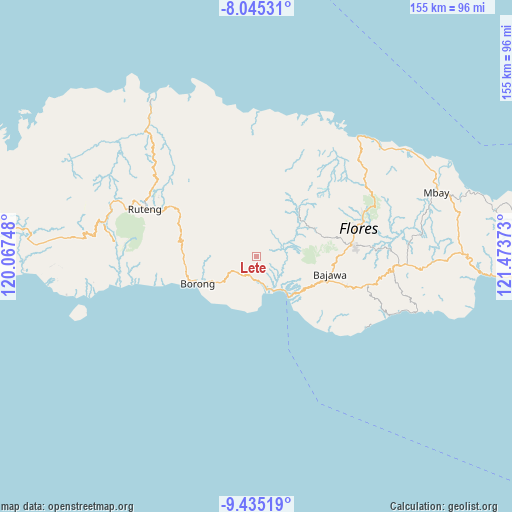
Lete GPS coordinates[2]
8° 44' 27.24" South, 120° 46' 14.16" East
| Map corner | latitude | longitude |
|---|---|---|
| Upper-left | -8.04531°, | 120.06748° |
| Center: | -8.7409°, | 120.7706° |
| Lower-right: | -9.43519°, | 121.47373° |
| Map W x H: | 154.5×154.5 km | = 96×96mi |
| max Lat: | 5.88969° ⇑90.2% North |
| Lete: | -8.7409° |
| min Lat: | ⇓9.8% South -10.934° |
| min Long | Lete | max Long |
| 95.1345° | 120.7706° | 140.9419° |
| W 85.2%⇐ | ⇒14.8% E |
Elevation
Elevation of Lete is 760 m = 2493 ft, and this is 530.3 m = 1740 ft above average elevation for this country.
| Max E: |
3185 m = 10449 ft | 6.2% |
| Lete | 760 m 2493 ft | |
| Avg. | 229.7 m = 754 ft | |
Min E: |
-1 m = -3 ft | 93.8% |
See also: Indonesia elevation on elevation.city.
Geographical zone
Lete is located in South Torrid zone (between Equator and Tropic of Capricorn). Distance of Equator is 971.9 km =603.9 mi to North.| Distance of | km | miles | from Lete |
|---|---|---|---|
| Equator | 971.9 | 603.9 | to North |
| Tropic Capricorn | 1634 | 1015.3 | to South |
| Antarctic Circle | 6429.3 | 3995 | to South |
| South Pole | 9035.2 | 5614.2 | to South |


Nearby cities:
15 places around Lete: (largest is in red/bold)
• Dalo
12.2 km =7.6 mi,  318°
318°
• Kipo
11 km =6.8 mi,  249°
249°
• Mukun
12.3 km =7.6 mi, 318°
• Munde
6.8 km =4.2 mi,  212°
212°
• Nggelok
10.3 km =6.4 mi,  354°
354°
• Ngusu
11 km =6.8 mi,  290°
290°
• Paukate
12.2 km =7.6 mi,  130°
130°
• Pedak
11.5 km =7.1 mi,  312°
312°
• Pejek
11.8 km =7.3 mi,  333°
333°
• Ranambeling
11.1 km =6.9 mi, 324°
• Tuwa
8 km =5 mi,  279°
279°
• Waekolong
4.9 km =3 mi, 247°
• Waelengga
10.3 km =6.4 mi,  156°
156°
• Waerana
7.6 km =4.7 mi,  233°
233°
• Watuka
6.8 km =4.2 mi,  256°
256°
Sources, notices
• [Note1] Compared only with cities in Indonesia existing in our database
• [Src1] Map data: © OpenStreetMap contributors (CC-BY-SA)
• [Src2] Other city data from geonames.org with taken over terms of usage.
• [Src3] Geographical zone / Annual Mean Temperature by Robert A. Rohde @ Wikipedia
