Munde geodata
Munde (East Nusa Tenggara) is a seat of a fourth-order administrative division; located in Indonesia in Asia/Makassar (GMT+8) time zone. In our database, there are 407 cities with bigger population. Compared to other cities in Indonesia, 91.3% of cities are located further ↑North; 85.1% of cities are located further ←West and 81.9% of cities have lower elevation than Munde. Note1


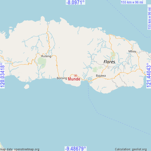
Munde GPS coordinates[2]
8° 47' 33.36" South, 120° 44' 14.28" East
| Map corner | latitude | longitude |
|---|---|---|
| Upper-left | -8.0971°, | 120.03418° |
| Center: | -8.7926°, | 120.7373° |
| Lower-right: | -9.48679°, | 121.44043° |
| Map W x H: | 154.5×154.5 km | = 96×96mi |
| max Lat: | 5.88969° ⇑91.3% North |
| Munde: | -8.7926° |
| min Lat: | ⇓8.7% South -10.934° |
| min Long | Munde | max Long |
| 95.1345° | 120.7373° | 140.9419° |
| W 85.1%⇐ | ⇒14.9% E |
Elevation
Elevation of Munde is 460 m = 1509 ft, and this is 230.3 m = 756 ft above average elevation for this country.
| Max E: |
3185 m = 10449 ft | 18.1% |
| Munde | 460 m 1509 ft | |
| Avg. | 229.7 m = 754 ft | |
Min E: |
-1 m = -3 ft | 81.9% |
See also: Indonesia elevation on elevation.city.
Geographical zone
Munde is located in South Torrid zone (between Equator and Tropic of Capricorn). Distance of Equator is 977.6 km =607.5 mi to North.| Distance of | km | miles | from Munde |
|---|---|---|---|
| Equator | 977.6 | 607.5 | to North |
| Tropic Capricorn | 1628.3 | 1011.8 | to South |
| Antarctic Circle | 6423.5 | 3991.4 | to South |
| South Pole | 9029.4 | 5610.6 | to South |


Nearby cities:
15 places around Munde: (largest is in red/bold)
• Aimere
14.4 km =8.9 mi,  112°
112°
• Borong
14.2 km =8.8 mi,  261°
261°
• Gurung
11.1 km =6.9 mi,  282°
282°
• Kipo
6.8 km =4.2 mi,  285°
285°
• Lete
6.8 km =4.2 mi,  32°
32°
• Lewe
11.5 km =7.1 mi,  298°
298°
• Muting
7.5 km =4.7 mi,  214°
214°
• Ngusu
11.6 km =7.2 mi,  325°
325°
• Paukate
13.1 km =8.1 mi,  99°
99°
• Sere
8.1 km =5 mi,  251°
251°
• Tuwa
8.2 km =5.1 mi, 328°
• Waekolong
3.9 km =2.4 mi,  347°
347°
• Waelengga
8.5 km =5.3 mi,  115°
115°
• Waerana
2.7 km =1.7 mi, 296°
• Watuka
5.1 km =3.2 mi,  324°
324°
Sources, notices
• [Note1] Compared only with cities in Indonesia existing in our database
• [Src1] Map data: © OpenStreetMap contributors (CC-BY-SA)
• [Src2] Other city data from geonames.org with taken over terms of usage.
• [Src3] Geographical zone / Annual Mean Temperature by Robert A. Rohde @ Wikipedia
