Panenggoede geodata
Panenggoede (East Nusa Tenggara) is a seat of a fourth-order administrative division; located in Indonesia in Asia/Makassar (GMT+8) time zone. In our database, there are 407 cities with bigger population. Compared to other cities in Indonesia, 94.4% of cities are located further ↑North; 81% of cities are located further ←West and 55.9% of cities have higher elevation than Panenggoede. Note1


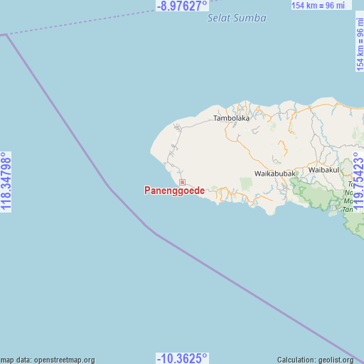
Panenggoede GPS coordinates[2]
9° 40' 12.36" South, 119° 3' 3.96" East
| Map corner | latitude | longitude |
|---|---|---|
| Upper-left | -8.97627°, | 118.34798° |
| Center: | -9.6701°, | 119.0511° |
| Lower-right: | -10.3625°, | 119.75423° |
| Map W x H: | 154.1×154.1 km | = 95.8×95.8mi |
| max Lat: | 5.88969° ⇑94.4% North |
| Panenggoede: | -9.6701° |
| min Lat: | ⇓5.6% South -10.934° |
| min Long | Panenggoede | max Long |
| 95.1345° | 119.0511° | 140.9419° |
| W 81%⇐ | ⇒19% E |
Elevation
Elevation of Panenggoede is 79 m = 259 ft, and this is 150.7 m = 494 ft below average elevation for this country.
| Max E: |
3185 m = 10449 ft | 55.9% |
| Avg. | 229.7 m = 754 ft | |
| Panenggoede | 79 m = 259 ft | |
Min E: |
-1 m = -3 ft | 44.1% |
See also: Indonesia elevation on elevation.city.
Geographical zone
Panenggoede is located in South Torrid zone (between Equator and Tropic of Capricorn). Distance of Equator is 1075.2 km =668.1 mi to North.| Distance of | km | miles | from Panenggoede |
|---|---|---|---|
| Equator | 1075.2 | 668.1 | to North |
| Tropic Capricorn | 1530.7 | 951.1 | to South |
| Antarctic Circle | 6326 | 3930.8 | to South |
| South Pole | 8931.8 | 5550 | to South |


Nearby cities:
15 places around Panenggoede: (largest is in red/bold)
• Batang
11.1 km =6.9 mi,  320°
320°
• Bondokodi
10.5 km =6.5 mi, 323°
• Dinjo
9.4 km =5.8 mi,  334°
334°
• Hamonggolele
11.7 km =7.3 mi, 328°
• Hohawungo
15.6 km =9.7 mi,  349°
349°
• Kahale
6.6 km =4.1 mi,  116°
116°
• Kaloghodalo
15.4 km =9.6 mi, 332°
• Kawangohari
15.3 km =9.5 mi,  339°
339°
• Leteloko
8.1 km =5 mi, 334°
• Lokorota
9.3 km =5.8 mi,  9°
9°
• Maliiha
13.5 km =8.4 mi, 345°
• Ngondokandawu
3 km =1.9 mi,  68°
68°
• Pasolapida
12.7 km =7.9 mi, 74°
• Waiha
3.9 km =2.4 mi, 346°
• Weetombo
14.3 km =8.9 mi,  36°
36°
Sources, notices
• [Note1] Compared only with cities in Indonesia existing in our database
• [Src1] Map data: © OpenStreetMap contributors (CC-BY-SA)
• [Src2] Other city data from geonames.org with taken over terms of usage.
• [Src3] Geographical zone / Annual Mean Temperature by Robert A. Rohde @ Wikipedia
