Pasolapida geodata
Pasolapida (East Nusa Tenggara) is a seat of a fourth-order administrative division; located in Indonesia in Asia/Makassar (GMT+8) time zone. In our database, there are 407 cities with bigger population. Compared to other cities in Indonesia, 94.2% of cities are located further ↑North; 81.1% of cities are located further ←West and 65.3% of cities have lower elevation than Pasolapida. Note1


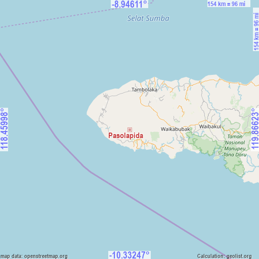
Pasolapida GPS coordinates[2]
9° 38' 24" South, 119° 9' 47.16" East
| Map corner | latitude | longitude |
|---|---|---|
| Upper-left | -8.94611°, | 118.45998° |
| Center: | -9.64°, | 119.1631° |
| Lower-right: | -10.33247°, | 119.86623° |
| Map W x H: | 154.1×154.2 km | = 95.8×95.8mi |
| max Lat: | 5.88969° ⇑94.2% North |
| Pasolapida: | -9.64° |
| min Lat: | ⇓5.8% South -10.934° |
| min Long | Pasolapida | max Long |
| 95.1345° | 119.1631° | 140.9419° |
| W 81.1%⇐ | ⇒18.9% E |
Elevation
Elevation of Pasolapida is 226 m = 741 ft, and this is 3.7 m = 12 ft below average elevation for this country.
| Max E: |
3185 m = 10449 ft | 34.7% |
| Avg. | 229.7 m = 754 ft | |
| Pasolapida | 226 m = 741 ft | |
Min E: |
-1 m = -3 ft | 65.3% |
See also: Indonesia elevation on elevation.city.
Geographical zone
Pasolapida is located in South Torrid zone (between Equator and Tropic of Capricorn). Distance of Equator is 1071.9 km =666 mi to North.| Distance of | km | miles | from Pasolapida |
|---|---|---|---|
| Equator | 1071.9 | 666 | to North |
| Tropic Capricorn | 1534.1 | 953.2 | to South |
| Antarctic Circle | 6329.3 | 3932.8 | to South |
| South Pole | 8935.2 | 5552.1 | to South |


Nearby cities:
15 places around Pasolapida: (largest is in red/bold)
• Delo
7.4 km =4.6 mi,  47°
47°
• Hodi
12.9 km =8 mi,  129°
129°
• Kahale
8.9 km =5.5 mi,  225°
225°
• Kalembutillu
12.5 km =7.8 mi,  44°
44°
• Lokorota
12.2 km =7.6 mi,  298°
298°
• Malulla
9.7 km =6 mi,  81°
81°
• Manola
9.4 km =5.8 mi,  26°
26°
• Ngondokandawu
9.8 km =6.1 mi,  256°
256°
• Panenggoede
12.7 km =7.9 mi,  254°
254°
• Pasonobenu
10 km =6.2 mi,  4°
4°
• Radamata
10.3 km =6.4 mi,  349°
349°
• Waiha
13.2 km =8.2 mi,  272°
272°
• Weekaka
10.3 km =6.4 mi, 37°
• Weekombaka
14.6 km =9.1 mi, 350°
• Weetombo
9.1 km =5.7 mi,  335°
335°
Sources, notices
• [Note1] Compared only with cities in Indonesia existing in our database
• [Src1] Map data: © OpenStreetMap contributors (CC-BY-SA)
• [Src2] Other city data from geonames.org with taken over terms of usage.
• [Src3] Geographical zone / Annual Mean Temperature by Robert A. Rohde @ Wikipedia
