Pejek geodata
Pejek (East Nusa Tenggara) is a seat of a fourth-order administrative division; located in Indonesia in Asia/Makassar (GMT+8) time zone. In our database, there are 407 cities with bigger population. Compared to other cities in Indonesia, 88% of cities are located further ↑North; 85.1% of cities are located further ←West and 97.4% of cities have lower elevation than Pejek. Note1


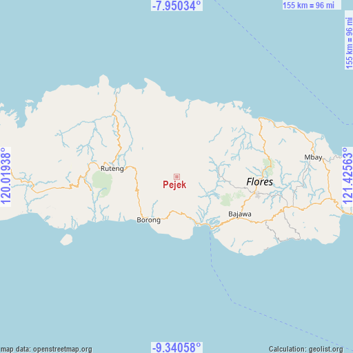
Pejek GPS coordinates[2]
8° 38' 45.96" South, 120° 43' 21" East
| Map corner | latitude | longitude |
|---|---|---|
| Upper-left | -7.95034°, | 120.01938° |
| Center: | -8.6461°, | 120.7225° |
| Lower-right: | -9.34058°, | 121.42563° |
| Map W x H: | 154.6×154.6 km | = 96.1×96.1mi |
| max Lat: | 5.88969° ⇑88% North |
| Pejek: | -8.6461° |
| min Lat: | ⇓12% South -10.934° |
| min Long | Pejek | max Long |
| 95.1345° | 120.7225° | 140.9419° |
| W 85.1%⇐ | ⇒14.9% E |
Elevation
Elevation of Pejek is 980 m = 3215 ft, and this is 750.3 m = 2462 ft above average elevation for this country.
| Max E: |
3185 m = 10449 ft | 2.6% |
| Pejek | 980 m 3215 ft | |
| Avg. | 229.7 m = 754 ft | |
Min E: |
-1 m = -3 ft | 97.4% |
See also: Indonesia elevation on elevation.city.
Geographical zone
Pejek is located in South Torrid zone (between Equator and Tropic of Capricorn). Distance of Equator is 961.4 km =597.4 mi to North.| Distance of | km | miles | from Pejek |
|---|---|---|---|
| Equator | 961.4 | 597.4 | to North |
| Tropic Capricorn | 1644.6 | 1021.9 | to South |
| Antarctic Circle | 6439.8 | 4001.5 | to South |
| South Pole | 9045.7 | 5620.7 | to South |


Nearby cities:
15 places around Pejek: (largest is in red/bold)
• Biting
11.2 km =7 mi,  299°
299°
• Dalo
3.2 km =2 mi,  242°
242°
• Lete
11.8 km =7.3 mi,  153°
153°
• Lurut
7 km =4.3 mi,  263°
263°
• Mukun
3.2 km =2 mi,  245°
245°
• Nggelok
4.3 km =2.7 mi,  94°
94°
• Ngkiong
11.3 km =7 mi,  320°
320°
• Ngkodal
9.1 km =5.7 mi,  356°
356°
• Ngkolong
10.6 km =6.6 mi, 356°
• Ngusu
8.4 km =5.2 mi,  216°
216°
• Pedak
4.3 km =2.7 mi,  229°
229°
• Ranambeling
1.8 km =1.1 mi, 215°
• Rantang
11.1 km =6.9 mi,  11°
11°
• Tuwa
9.6 km =6 mi,  195°
195°
• Waling
9.3 km =5.8 mi,  269°
269°
Sources, notices
• [Note1] Compared only with cities in Indonesia existing in our database
• [Src1] Map data: © OpenStreetMap contributors (CC-BY-SA)
• [Src2] Other city data from geonames.org with taken over terms of usage.
• [Src3] Geographical zone / Annual Mean Temperature by Robert A. Rohde @ Wikipedia
