Padhahegha geodata
Padhahegha (East Nusa Tenggara) is a seat of a fourth-order administrative division; located in Indonesia in Asia/Makassar (GMT+8) time zone. In our database, there are 407 cities with bigger population. Compared to other cities in Indonesia, 90.8% of cities are located further ↑North; 85.9% of cities are located further ←West and 88.7% of cities have lower elevation than Padhahegha. Note1


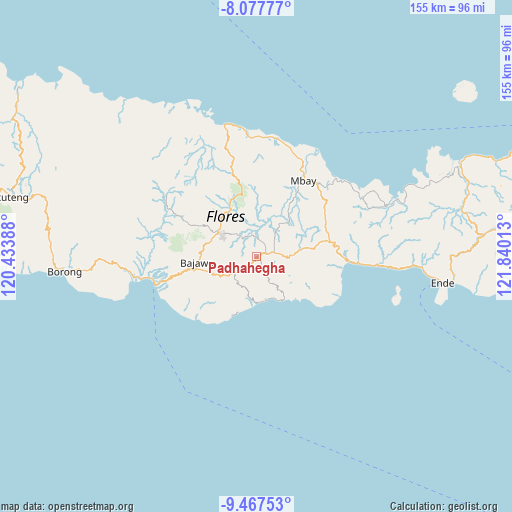
Padhahegha GPS coordinates[2]
8° 46' 23.88" South, 121° 8' 13.2" East
| Map corner | latitude | longitude |
|---|---|---|
| Upper-left | -8.07777°, | 120.43388° |
| Center: | -8.7733°, | 121.137° |
| Lower-right: | -9.46753°, | 121.84013° |
| Map W x H: | 154.5×154.5 km | = 96×96mi |
| max Lat: | 5.88969° ⇑90.8% North |
| Padhahegha: | -8.7733° |
| min Lat: | ⇓9.2% South -10.934° |
| min Long | Padhahegha | max Long |
| 95.1345° | 121.137° | 140.9419° |
| W 85.9%⇐ | ⇒14.1% E |
Elevation
Elevation of Padhahegha is 601 m = 1972 ft, and this is 371.3 m = 1218 ft above average elevation for this country.
| Max E: |
3185 m = 10449 ft | 11.3% |
| Padhahegha | 601 m 1972 ft | |
| Avg. | 229.7 m = 754 ft | |
Min E: |
-1 m = -3 ft | 88.7% |
See also: Indonesia elevation on elevation.city.
Geographical zone
Padhahegha is located in South Torrid zone (between Equator and Tropic of Capricorn). Distance of Equator is 975.5 km =606.1 mi to North.| Distance of | km | miles | from Padhahegha |
|---|---|---|---|
| Equator | 975.5 | 606.1 | to North |
| Tropic Capricorn | 1630.4 | 1013.1 | to South |
| Antarctic Circle | 6425.7 | 3992.7 | to South |
| South Pole | 9031.6 | 5612 | to South |


Nearby cities:
15 places around Padhahegha: (largest is in red/bold)
• Boawae
3.7 km =2.3 mi,  73°
73°
• Doya
6.2 km =3.9 mi,  153°
153°
• Gero
9.5 km =5.9 mi,  36°
36°
• Hobonio
1.9 km =1.2 mi,  220°
220°
• Mataloko
9.7 km =6 mi,  237°
237°
• Mulakoli
9.5 km =5.9 mi,  111°
111°
• Nunukae
3.6 km =2.2 mi, 150°
• Pogo
4 km =2.5 mi,  230°
230°
• Rega
7.9 km =4.9 mi,  85°
85°
• Taka
7.9 km =4.9 mi,  198°
198°
• Tibakisa
4.9 km =3 mi, 68°
• Watugase
7.1 km =4.4 mi,  48°
48°
• Wolonio
9.1 km =5.7 mi,  97°
97°
• Wudu
7.3 km =4.5 mi, 90°
• Zepe
4.8 km =3 mi,  276°
276°
Sources, notices
• [Note1] Compared only with cities in Indonesia existing in our database
• [Src1] Map data: © OpenStreetMap contributors (CC-BY-SA)
• [Src2] Other city data from geonames.org with taken over terms of usage.
• [Src3] Geographical zone / Annual Mean Temperature by Robert A. Rohde @ Wikipedia
