Kepatihan geodata
Kepatihan (East Java) is a seat of a fourth-order administrative division; located in Indonesia in Asia/Jakarta (GMT+7) time zone. In our database, there are 407 cities with bigger population. Compared to other cities in Indonesia, 63.9% of cities are located further ↑North; 51.1% of cities are located further →East and 52.7% of cities have higher elevation than Kepatihan. Note1


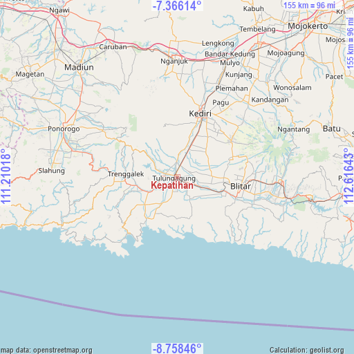
Kepatihan GPS coordinates[2]
8° 3' 46.44" South, 111° 54' 47.88" East
| Map corner | latitude | longitude |
|---|---|---|
| Upper-left | -7.36614°, | 111.21018° |
| Center: | -8.0629°, | 111.9133° |
| Lower-right: | -8.75846°, | 112.61643° |
| Map W x H: | 154.8×154.8 km | = 96.2×96.2mi |
| max Lat: | 5.88969° ⇑63.9% North |
| Kepatihan: | -8.0629° |
| min Lat: | ⇓36.1% South -10.934° |
| min Long | Kepatihan | max Long |
| 95.1345° | 111.9133° | 140.9419° |
| W 48.9%⇐ | ⇒51.1% E |
Elevation
Elevation of Kepatihan is 93 m = 305 ft, and this is 136.7 m = 448 ft below average elevation for this country.
| Max E: |
3185 m = 10449 ft | 52.7% |
| Avg. | 229.7 m = 754 ft | |
| Kepatihan | 93 m = 305 ft | |
Min E: |
-1 m = -3 ft | 47.3% |
See also: Indonesia elevation on elevation.city.
Geographical zone
Kepatihan is located in South Torrid zone (between Equator and Tropic of Capricorn). Distance of Equator is 896.5 km =557.1 mi to North.| Distance of | km | miles | from Kepatihan |
|---|---|---|---|
| Equator | 896.5 | 557.1 | to North |
| Tropic Capricorn | 1709.4 | 1062.2 | to South |
| Antarctic Circle | 6504.7 | 4041.8 | to South |
| South Pole | 9110.6 | 5661.1 | to South |


Nearby cities:
15 places around Kepatihan: (largest is in red/bold)
• Bago
0.8 km =0.5 mi,  217°
217°
• Jepun
1.4 km =0.9 mi,  191°
191°
• Kanugrahan
2.1 km =1.3 mi,  312°
312°
• Karangwaru
1.8 km =1.1 mi,  243°
243°
• Kauman
1.9 km =1.2 mi,  263°
263°
• Kedungtaman
0.9 km =0.6 mi,  347°
347°
• Kedungwaru
0.6 km =0.4 mi,  138°
138°
• Kudusan
2.3 km =1.4 mi, 139°
• Mekarsari
1.2 km =0.7 mi,  100°
100°
• Rejoagung
2.1 km =1.3 mi,  0°
0°
• Ringinagung
2.1 km =1.3 mi,  83°
83°
• Sembung
1.9 km =1.2 mi,  276°
276°
• Serut
2.1 km =1.3 mi, 191°
• Tamanan
1.6 km =1 mi,  228°
228°
• Tulungagung
1.2 km =0.7 mi, 255°
Sources, notices
• [Note1] Compared only with cities in Indonesia existing in our database
• [Src1] Map data: © OpenStreetMap contributors (CC-BY-SA)
• [Src2] Other city data from geonames.org with taken over terms of usage.
• [Src3] Geographical zone / Annual Mean Temperature by Robert A. Rohde @ Wikipedia
