Loa geodata
Loa (East Nusa Tenggara) is a seat of a fourth-order administrative division; located in Indonesia in Asia/Makassar (GMT+8) time zone. In our database, there are 407 cities with bigger population. Compared to other cities in Indonesia, 89.8% of cities are located further ↑North; 85.7% of cities are located further ←West and 84% of cities have lower elevation than Loa. Note1


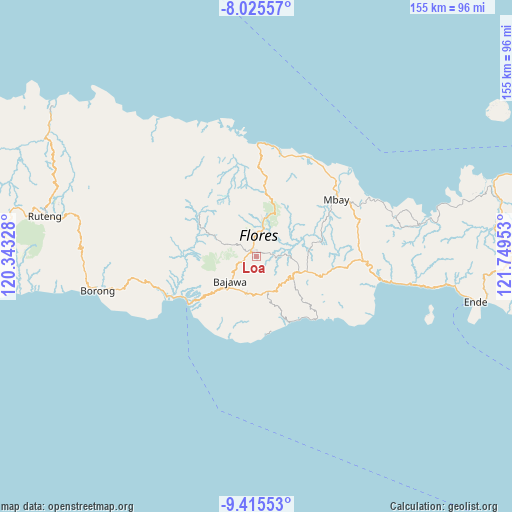
Loa GPS coordinates[2]
8° 43' 16.32" South, 121° 2' 47.04" East
| Map corner | latitude | longitude |
|---|---|---|
| Upper-left | -8.02557°, | 120.34328° |
| Center: | -8.7212°, | 121.0464° |
| Lower-right: | -9.41553°, | 121.74953° |
| Map W x H: | 154.5×154.6 km | = 96×96.1mi |
| max Lat: | 5.88969° ⇑89.8% North |
| Loa: | -8.7212° |
| min Lat: | ⇓10.2% South -10.934° |
| min Long | Loa | max Long |
| 95.1345° | 121.0464° | 140.9419° |
| W 85.7%⇐ | ⇒14.3% E |
Elevation
Elevation of Loa is 500 m = 1640 ft, and this is 270.3 m = 887 ft above average elevation for this country.
| Max E: |
3185 m = 10449 ft | 16% |
| Loa | 500 m 1640 ft | |
| Avg. | 229.7 m = 754 ft | |
Min E: |
-1 m = -3 ft | 84% |
See also: Indonesia elevation on elevation.city.
Geographical zone
Loa is located in South Torrid zone (between Equator and Tropic of Capricorn). Distance of Equator is 969.7 km =602.5 mi to North.| Distance of | km | miles | from Loa |
|---|---|---|---|
| Equator | 969.7 | 602.5 | to North |
| Tropic Capricorn | 1636.2 | 1016.7 | to South |
| Antarctic Circle | 6431.5 | 3996.3 | to South |
| South Pole | 9037.4 | 5615.6 | to South |


Nearby cities:
15 places around Loa: (largest is in red/bold)
• Anafolo
0.3 km =0.2 mi,  279°
279°
• Bajawa
10.6 km =6.6 mi,  228°
228°
• Bogenga
11.2 km =7 mi,  236°
236°
• Lekosoro
10 km =6.2 mi, 227°
• Masu
1.3 km =0.8 mi,  325°
325°
• Mataloko
11.2 km =7 mi,  170°
170°
• Naru
8.2 km =5.1 mi, 233°
• Ngedukelu
10.8 km =6.7 mi, 226°
• Piga
0.8 km =0.5 mi,  5°
5°
• Pogo
10.8 km =6.7 mi,  140°
140°
• Soa
2.8 km =1.7 mi,  336°
336°
• Tanalodu
11.1 km =6.9 mi, 225°
• Trikora
11 km =6.8 mi, 228°
• Waepana
3.3 km =2.1 mi, 343°
• Zepe
7.3 km =4.5 mi, 135°
Sources, notices
• [Note1] Compared only with cities in Indonesia existing in our database
• [Src1] Map data: © OpenStreetMap contributors (CC-BY-SA)
• [Src2] Other city data from geonames.org with taken over terms of usage.
• [Src3] Geographical zone / Annual Mean Temperature by Robert A. Rohde @ Wikipedia
