Masu geodata
Masu (East Nusa Tenggara) is a seat of a fourth-order administrative division; located in Indonesia in Asia/Makassar (GMT+8) time zone. In our database, there are 407 cities with bigger population. Compared to other cities in Indonesia, 89.5% of cities are located further ↑North; 85.7% of cities are located further ←West and 87.2% of cities have lower elevation than Masu. Note1


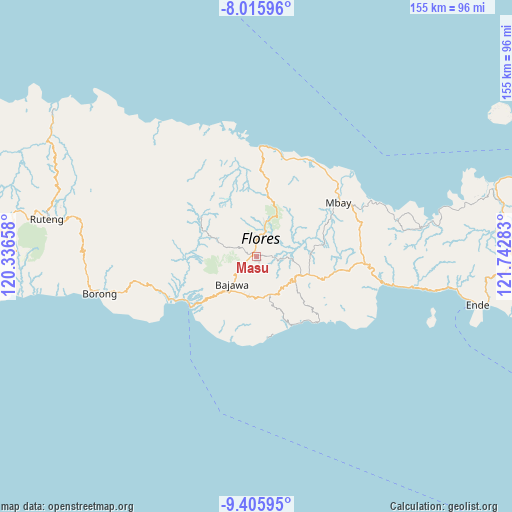
Masu GPS coordinates[2]
8° 42' 41.76" South, 121° 2' 22.92" East
| Map corner | latitude | longitude |
|---|---|---|
| Upper-left | -8.01596°, | 120.33658° |
| Center: | -8.7116°, | 121.0397° |
| Lower-right: | -9.40595°, | 121.74283° |
| Map W x H: | 154.6×154.6 km | = 96.1×96.1mi |
| max Lat: | 5.88969° ⇑89.5% North |
| Masu: | -8.7116° |
| min Lat: | ⇓10.5% South -10.934° |
| min Long | Masu | max Long |
| 95.1345° | 121.0397° | 140.9419° |
| W 85.7%⇐ | ⇒14.3% E |
Elevation
Elevation of Masu is 560 m = 1837 ft, and this is 330.3 m = 1084 ft above average elevation for this country.
| Max E: |
3185 m = 10449 ft | 12.8% |
| Masu | 560 m 1837 ft | |
| Avg. | 229.7 m = 754 ft | |
Min E: |
-1 m = -3 ft | 87.2% |
See also: Indonesia elevation on elevation.city.
Geographical zone
Masu is located in South Torrid zone (between Equator and Tropic of Capricorn). Distance of Equator is 968.6 km =601.9 mi to North.| Distance of | km | miles | from Masu |
|---|---|---|---|
| Equator | 968.6 | 601.9 | to North |
| Tropic Capricorn | 1637.3 | 1017.4 | to South |
| Antarctic Circle | 6432.5 | 3997 | to South |
| South Pole | 9038.4 | 5616.2 | to South |


Nearby cities:
15 places around Masu: (largest is in red/bold)
• Anafolo
1.1 km =0.7 mi,  157°
157°
• Bajawa
10.9 km =6.8 mi,  221°
221°
• Bogenga
11.3 km =7 mi,  229°
229°
• Kisanata
11.6 km =7.2 mi, 221°
• Lekosoro
10.3 km =6.4 mi, 220°
• Loa
1.3 km =0.8 mi,  145°
145°
• Malapaubhara
11.8 km =7.3 mi,  52°
52°
• Naru
8.3 km =5.2 mi, 224°
• Ngedukelu
11.1 km =6.9 mi, 220°
• Piga
0.9 km =0.6 mi,  108°
108°
• Soa
1.6 km =1 mi,  345°
345°
• Tanalodu
11.4 km =7.1 mi, 219°
• Trikora
11.2 km =7 mi, 221°
• Waepana
2.1 km =1.3 mi, 354°
• Zepe
8.6 km =5.3 mi,  136°
136°
Sources, notices
• [Note1] Compared only with cities in Indonesia existing in our database
• [Src1] Map data: © OpenStreetMap contributors (CC-BY-SA)
• [Src2] Other city data from geonames.org with taken over terms of usage.
• [Src3] Geographical zone / Annual Mean Temperature by Robert A. Rohde @ Wikipedia
