Zepe geodata
Zepe (East Nusa Tenggara) is a seat of a fourth-order administrative division; located in Indonesia in Asia/Makassar (GMT+8) time zone. In our database, there are 407 cities with bigger population. Compared to other cities in Indonesia, 90.8% of cities are located further ↑North; 85.8% of cities are located further ←West and 86.4% of cities have lower elevation than Zepe. Note1


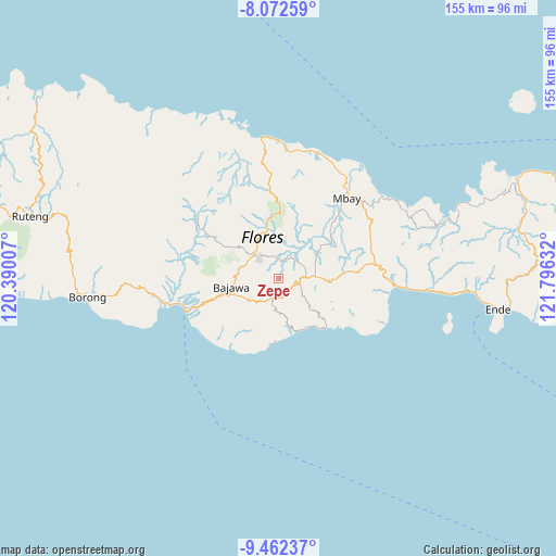
Zepe GPS coordinates[2]
8° 46' 5.268" South, 121° 5' 35.484" East
| Map corner | latitude | longitude |
|---|---|---|
| Upper-left | -8.07259°, | 120.39007° |
| Center: | -8.76813°, | 121.09319° |
| Lower-right: | -9.46237°, | 121.79632° |
| Map W x H: | 154.5×154.5 km | = 96×96mi |
| max Lat: | 5.88969° ⇑90.8% North |
| Zepe: | -8.76813° |
| min Lat: | ⇓9.2% South -10.934° |
| min Long | Zepe | max Long |
| 95.1345° | 121.09319° | 140.9419° |
| W 85.8%⇐ | ⇒14.2% E |
Elevation
Elevation of Zepe is 543 m = 1781 ft, and this is 313.3 m = 1028 ft above average elevation for this country.
| Max E: |
3185 m = 10449 ft | 13.6% |
| Zepe | 543 m 1781 ft | |
| Avg. | 229.7 m = 754 ft | |
Min E: |
-1 m = -3 ft | 86.4% |
See also: Indonesia elevation on elevation.city.
Geographical zone
Zepe is located in South Torrid zone (between Equator and Tropic of Capricorn). Distance of Equator is 974.9 km =605.8 mi to North.| Distance of | km | miles | from Zepe |
|---|---|---|---|
| Equator | 974.9 | 605.8 | to North |
| Tropic Capricorn | 1631 | 1013.5 | to South |
| Antarctic Circle | 6426.2 | 3993.1 | to South |
| South Pole | 9032.1 | 5612.3 | to South |


Nearby cities:
15 places around Zepe: (largest is in red/bold)
• Anafolo
7.6 km =4.7 mi,  314°
314°
• Boawae
8.4 km =5.2 mi,  86°
86°
• Dorupare
7.5 km =4.7 mi,  215°
215°
• Gisiliba
8.3 km =5.2 mi,  212°
212°
• Hobonio
4.1 km =2.5 mi,  120°
120°
• Jadho
9.5 km =5.9 mi, 209°
• Loa
7.3 km =4.5 mi,  315°
315°
• Masu
8.6 km =5.3 mi, 316°
• Mataloko
6.7 km =4.2 mi, 209°
• Nunukae
7.5 km =4.7 mi, 119°
• Padhahegha
4.8 km =3 mi,  96°
96°
• Piga
7.9 km =4.9 mi, 319°
• Pogo
3.6 km =2.2 mi,  151°
151°
• Taka
8.4 km =5.2 mi,  164°
164°
• Tibakisa
9.5 km =5.9 mi,  82°
82°
Sources, notices
• [Note1] Compared only with cities in Indonesia existing in our database
• [Src1] Map data: © OpenStreetMap contributors (CC-BY-SA)
• [Src2] Other city data from geonames.org with taken over terms of usage.
• [Src3] Geographical zone / Annual Mean Temperature by Robert A. Rohde @ Wikipedia
