Piga geodata
Piga (East Nusa Tenggara) is a seat of a fourth-order administrative division; located in Indonesia in Asia/Makassar (GMT+8) time zone. In our database, there are 407 cities with bigger population. Compared to other cities in Indonesia, 89.6% of cities are located further ↑North; 85.7% of cities are located further ←West and 83.3% of cities have lower elevation than Piga. Note1


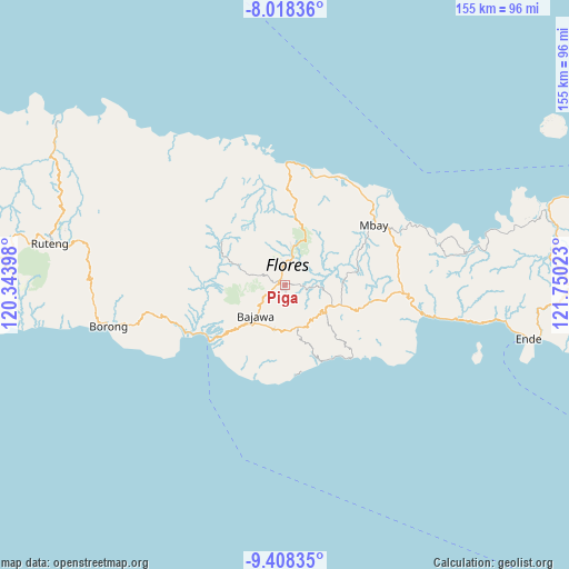
Piga GPS coordinates[2]
8° 42' 50.4" South, 121° 2' 49.56" East
| Map corner | latitude | longitude |
|---|---|---|
| Upper-left | -8.01836°, | 120.34398° |
| Center: | -8.714°, | 121.0471° |
| Lower-right: | -9.40835°, | 121.75023° |
| Map W x H: | 154.6×154.6 km | = 96.1×96.1mi |
| max Lat: | 5.88969° ⇑89.6% North |
| Piga: | -8.714° |
| min Lat: | ⇓10.4% South -10.934° |
| min Long | Piga | max Long |
| 95.1345° | 121.0471° | 140.9419° |
| W 85.7%⇐ | ⇒14.3% E |
Elevation
Elevation of Piga is 486 m = 1594 ft, and this is 256.3 m = 841 ft above average elevation for this country.
| Max E: |
3185 m = 10449 ft | 16.7% |
| Piga | 486 m 1594 ft | |
| Avg. | 229.7 m = 754 ft | |
Min E: |
-1 m = -3 ft | 83.3% |
See also: Indonesia elevation on elevation.city.
Geographical zone
Piga is located in South Torrid zone (between Equator and Tropic of Capricorn). Distance of Equator is 968.9 km =602 mi to North.| Distance of | km | miles | from Piga |
|---|---|---|---|
| Equator | 968.9 | 602 | to North |
| Tropic Capricorn | 1637 | 1017.2 | to South |
| Antarctic Circle | 6432.3 | 3996.8 | to South |
| South Pole | 9038.2 | 5616.1 | to South |


Nearby cities:
15 places around Piga: (largest is in red/bold)
• Anafolo
0.8 km =0.5 mi,  207°
207°
• Bajawa
11.2 km =7 mi,  225°
225°
• Bogenga
11.7 km =7.3 mi, 233°
• Lekosoro
10.7 km =6.6 mi,  224°
224°
• Loa
0.8 km =0.5 mi,  185°
185°
• Malapaubhara
11.3 km =7 mi,  48°
48°
• Masu
0.9 km =0.6 mi,  288°
288°
• Naru
8.7 km =5.4 mi, 229°
• Ngedukelu
11.4 km =7.1 mi, 224°
• Pogo
11.4 km =7.1 mi,  143°
143°
• Soa
2.1 km =1.3 mi,  325°
325°
• Tanalodu
11.7 km =7.3 mi, 223°
• Trikora
11.6 km =7.2 mi, 225°
• Waepana
2.6 km =1.6 mi,  336°
336°
• Zepe
7.9 km =4.9 mi, 139°
Sources, notices
• [Note1] Compared only with cities in Indonesia existing in our database
• [Src1] Map data: © OpenStreetMap contributors (CC-BY-SA)
• [Src2] Other city data from geonames.org with taken over terms of usage.
• [Src3] Geographical zone / Annual Mean Temperature by Robert A. Rohde @ Wikipedia
