Peusar geodata
Peusar (Banten) is a seat of a fourth-order administrative division; located in Indonesia in Asia/Jakarta (GMT+7) time zone. In our database, there are 407 cities with bigger population. Compared to other cities in Indonesia, 82.1% of cities are located further ↓South; 93.9% of cities are located further →East and 52% of cities have lower elevation than Peusar. Note1


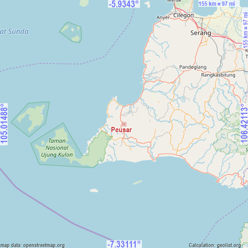
Peusar GPS coordinates[2]
6° 37' 59.52" South, 105° 43' 4.8" East
| Map corner | latitude | longitude |
|---|---|---|
| Upper-left | -5.9343°, | 105.01488° |
| Center: | -6.6332°, | 105.718° |
| Lower-right: | -7.33111°, | 106.42113° |
| Map W x H: | 155.3×155.3 km | = 96.5×96.5mi |
| max Lat: | 5.88969° ⇑17.9% North |
| Peusar: | -6.6332° |
| min Lat: | ⇓82.1% South -10.934° |
| min Long | Peusar | max Long |
| 95.1345° | 105.718° | 140.9419° |
| W 6.1%⇐ | ⇒93.9% E |
Elevation
Elevation of Peusar is 110 m = 361 ft, and this is 119.7 m = 393 ft below average elevation for this country.
| Max E: |
3185 m = 10449 ft | 48% |
| Avg. | 229.7 m = 754 ft | |
| Peusar | 110 m = 361 ft | |
Min E: |
-1 m = -3 ft | 52% |
See also: Indonesia elevation on elevation.city.
Geographical zone
Peusar is located in South Torrid zone (between Equator and Tropic of Capricorn). Distance of Equator is 737.5 km =458.3 mi to North.| Distance of | km | miles | from Peusar |
|---|---|---|---|
| Equator | 737.5 | 458.3 | to North |
| Tropic Capricorn | 1868.4 | 1161 | to South |
| Antarctic Circle | 6663.6 | 4140.6 | to South |
| South Pole | 9269.5 | 5759.8 | to South |


Nearby cities:
15 places around Peusar: (largest is in red/bold)
• Babakanbungur
9.1 km =5.7 mi,  347°
347°
• Babakantengah
2.4 km =1.5 mi,  245°
245°
• Cangkeuteuk
8.8 km =5.5 mi,  63°
63°
• Cibaliung
8 km =5 mi,  181°
181°
• Cigeulis
5.8 km =3.6 mi,  330°
330°
• Cijalarang
6.3 km =3.9 mi,  236°
236°
• Cikadondongdesa
3.8 km =2.4 mi,  215°
215°
• Ciseureuheun
3.8 km =2.4 mi,  355°
355°
• Gunungkendeng
5.4 km =3.4 mi,  196°
196°
• Karangbolong
7.5 km =4.7 mi,  273°
273°
• Marapat
3.5 km =2.2 mi,  317°
317°
• Salam
6.5 km =4 mi, 180°
• Sobang
9 km =5.6 mi,  28°
28°
• Songgom
8.3 km =5.2 mi,  19°
19°
• Sukajadi
9.1 km =5.7 mi,  188°
188°
Sources, notices
• [Note1] Compared only with cities in Indonesia existing in our database
• [Src1] Map data: © OpenStreetMap contributors (CC-BY-SA)
• [Src2] Other city data from geonames.org with taken over terms of usage.
• [Src3] Geographical zone / Annual Mean Temperature by Robert A. Rohde @ Wikipedia
