Cangkeuteuk geodata
Cangkeuteuk (Banten) is a seat of a fourth-order administrative division; located in Indonesia in Asia/Jakarta (GMT+7) time zone. In our database, there are 407 cities with bigger population. Compared to other cities in Indonesia, 82.7% of cities are located further ↓South; 93.7% of cities are located further →East and 64.5% of cities have higher elevation than Cangkeuteuk. Note1


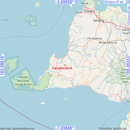
Cangkeuteuk GPS coordinates[2]
6° 35' 54.6" South, 105° 47' 21.48" East
| Map corner | latitude | longitude |
|---|---|---|
| Upper-left | -5.89956°, | 105.08618° |
| Center: | -6.5985°, | 105.7893° |
| Lower-right: | -7.29646°, | 106.49243° |
| Map W x H: | 155.3×155.3 km | = 96.5×96.5mi |
| max Lat: | 5.88969° ⇑17.3% North |
| Cangkeuteuk: | -6.5985° |
| min Lat: | ⇓82.7% South -10.934° |
| min Long | Cangkeuteuk | max Long |
| 95.1345° | 105.7893° | 140.9419° |
| W 6.3%⇐ | ⇒93.7% E |
Elevation
Elevation of Cangkeuteuk is 44 m = 144 ft, and this is 185.7 m = 609 ft below average elevation for this country.
| Max E: |
3185 m = 10449 ft | 64.5% |
| Avg. | 229.7 m = 754 ft | |
| Cangkeuteuk | 44 m = 144 ft | |
Min E: |
-1 m = -3 ft | 35.5% |
See also: Indonesia elevation on elevation.city.
Geographical zone
Cangkeuteuk is located in South Torrid zone (between Equator and Tropic of Capricorn). Distance of Equator is 733.7 km =455.9 mi to North.| Distance of | km | miles | from Cangkeuteuk |
|---|---|---|---|
| Equator | 733.7 | 455.9 | to North |
| Tropic Capricorn | 1872.2 | 1163.3 | to South |
| Antarctic Circle | 6667.5 | 4143 | to South |
| South Pole | 9273.4 | 5762.2 | to South |


Nearby cities:
15 places around Cangkeuteuk: (largest is in red/bold)
• Awilega
7.4 km =4.6 mi,  61°
61°
• Bojen Kulon
3.9 km =2.4 mi,  357°
357°
• Carodok
7 km =4.3 mi,  75°
75°
• Cibodas
7.7 km =4.8 mi,  85°
85°
• Cimara
4.3 km =2.7 mi,  68°
68°
• Cipinang
8.3 km =5.2 mi,  96°
96°
• Ciseureuheun
8.2 km =5.1 mi,  269°
269°
• Kalapadua
8.2 km =5.1 mi, 62°
• Pangkalan
5.7 km =3.5 mi,  321°
321°
• Perintis
8 km =5 mi,  10°
10°
• Peusar
8.8 km =5.5 mi,  243°
243°
• Seuseupan
6.7 km =4.2 mi,  29°
29°
• Sobang
5.4 km =3.4 mi, 318°
• Songgom
6.5 km =4 mi,  307°
307°
• Sumurwaru
3.1 km =1.9 mi,  38°
38°
Sources, notices
• [Note1] Compared only with cities in Indonesia existing in our database
• [Src1] Map data: © OpenStreetMap contributors (CC-BY-SA)
• [Src2] Other city data from geonames.org with taken over terms of usage.
• [Src3] Geographical zone / Annual Mean Temperature by Robert A. Rohde @ Wikipedia
