Polos geodata
Polos (Banten) is a seat of a third-order administrative division; located in Indonesia in Asia/Jakarta (GMT+7) time zone. In our database, there are 407 cities with bigger population. Compared to other cities in Indonesia, 80.7% of cities are located further ↓South; 94.2% of cities are located further →East and 66.2% of cities have lower elevation than Polos. Note1


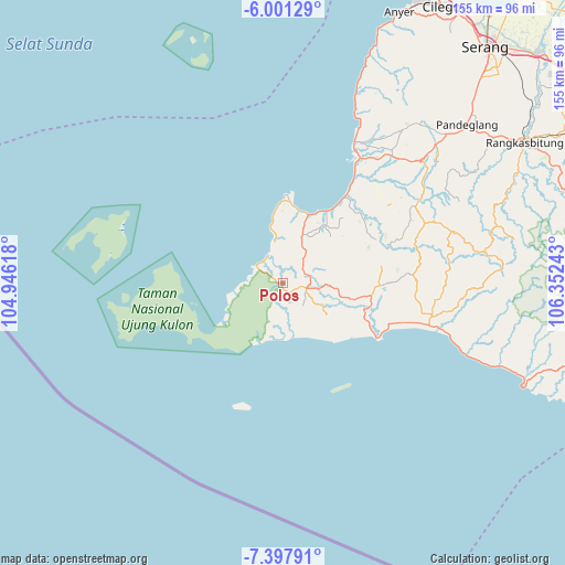
Polos GPS coordinates[2]
6° 42' 0.36" South, 105° 38' 57.48" East
| Map corner | latitude | longitude |
|---|---|---|
| Upper-left | -6.00129°, | 104.94618° |
| Center: | -6.7001°, | 105.6493° |
| Lower-right: | -7.39791°, | 106.35243° |
| Map W x H: | 155.3×155.3 km | = 96.5×96.5mi |
| max Lat: | 5.88969° ⇑19.3% North |
| Polos: | -6.7001° |
| min Lat: | ⇓80.7% South -10.934° |
| min Long | Polos | max Long |
| 95.1345° | 105.6493° | 140.9419° |
| W 5.8%⇐ | ⇒94.2% E |
Elevation
Elevation of Polos is 241 m = 791 ft, and this is 11.3 m = 37 ft above average elevation for this country.
| Max E: |
3185 m = 10449 ft | 33.8% |
| Polos | 241 m 791 ft | |
| Avg. | 229.7 m = 754 ft | |
Min E: |
-1 m = -3 ft | 66.2% |
See also: Indonesia elevation on elevation.city.
Geographical zone
Polos is located in South Torrid zone (between Equator and Tropic of Capricorn). Distance of Equator is 745 km =462.9 mi to North.| Distance of | km | miles | from Polos |
|---|---|---|---|
| Equator | 745 | 462.9 | to North |
| Tropic Capricorn | 1860.9 | 1156.3 | to South |
| Antarctic Circle | 6656.2 | 4136 | to South |
| South Pole | 9262.1 | 5755.2 | to South |


Nearby cities:
15 places around Polos: (largest is in red/bold)
• Babakantengah
8.4 km =5.2 mi,  39°
39°
• Babakantonggoh
2.3 km =1.4 mi,  285°
285°
• Cangkeuteuk Sabrang
3.9 km =2.4 mi,  221°
221°
• Cibaliung
7.4 km =4.6 mi,  94°
94°
• Ciburial
3.3 km =2.1 mi,  144°
144°
• Cijalarang
4.6 km =2.9 mi,  30°
30°
• Cikadondongdesa
6.9 km =4.3 mi,  51°
51°
• Cikadu
7.6 km =4.7 mi,  131°
131°
• Ciunil Barat
1.6 km =1 mi,  79°
79°
• Gunungkendeng
6.5 km =4 mi,  69°
69°
• Karangbolong
7.9 km =4.9 mi,  0°
0°
• Pematangluhur
7.8 km =4.8 mi,  182°
182°
• Rancasadang
7.1 km =4.4 mi,  150°
150°
• Salam
7.6 km =4.7 mi, 82°
• Sukajadi
6.5 km =4 mi,  104°
104°
Sources, notices
• [Note1] Compared only with cities in Indonesia existing in our database
• [Src1] Map data: © OpenStreetMap contributors (CC-BY-SA)
• [Src2] Other city data from geonames.org with taken over terms of usage.
• [Src3] Geographical zone / Annual Mean Temperature by Robert A. Rohde @ Wikipedia
