Ciburial geodata
Ciburial (Banten) is a seat of a fourth-order administrative division; located in Indonesia in Asia/Jakarta (GMT+7) time zone. In our database, there are 407 cities with bigger population. Compared to other cities in Indonesia, 79.4% of cities are located further ↓South; 94.2% of cities are located further →East and 61% of cities have lower elevation than Ciburial. Note1


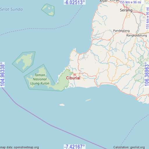
Ciburial GPS coordinates[2]
6° 43' 26.04" South, 105° 39' 59.4" East
| Map corner | latitude | longitude |
|---|---|---|
| Upper-left | -6.02513°, | 104.96338° |
| Center: | -6.7239°, | 105.6665° |
| Lower-right: | -7.42167°, | 106.36963° |
| Map W x H: | 155.3×155.3 km | = 96.5×96.5mi |
| max Lat: | 5.88969° ⇑20.6% North |
| Ciburial: | -6.7239° |
| min Lat: | ⇓79.4% South -10.934° |
| min Long | Ciburial | max Long |
| 95.1345° | 105.6665° | 140.9419° |
| W 5.8%⇐ | ⇒94.2% E |
Elevation
Elevation of Ciburial is 174 m = 571 ft, and this is 55.7 m = 183 ft below average elevation for this country.
| Max E: |
3185 m = 10449 ft | 39% |
| Avg. | 229.7 m = 754 ft | |
| Ciburial | 174 m = 571 ft | |
Min E: |
-1 m = -3 ft | 61% |
See also: Indonesia elevation on elevation.city.
Geographical zone
Ciburial is located in South Torrid zone (between Equator and Tropic of Capricorn). Distance of Equator is 747.6 km =464.5 mi to North.| Distance of | km | miles | from Ciburial |
|---|---|---|---|
| Equator | 747.6 | 464.5 | to North |
| Tropic Capricorn | 1858.3 | 1154.7 | to South |
| Antarctic Circle | 6653.5 | 4134.3 | to South |
| South Pole | 9259.4 | 5753.5 | to South |


Nearby cities:
15 places around Ciburial: (largest is in red/bold)
• Babakantonggoh
5.2 km =3.2 mi,  308°
308°
• Cangkeuteuk Sabrang
4.5 km =2.8 mi,  266°
266°
• Cibaliung
5.9 km =3.7 mi,  68°
68°
• Cijalarang
6.6 km =4.1 mi,  3°
3°
• Cikadu
4.5 km =2.8 mi,  122°
122°
• Cinyurup
6.7 km =4.2 mi,  152°
152°
• Ciunil Barat
3 km =1.9 mi,  354°
354°
• Gunungkendeng
6.5 km =4 mi,  40°
40°
• Pematangluhur
5.7 km =3.5 mi,  203°
203°
• Polos
3.3 km =2.1 mi,  324°
324°
• Rancasadang
3.8 km =2.4 mi,  156°
156°
• Salam
6.7 km =4.2 mi,  57°
57°
• Sindanglaya
5.9 km =3.7 mi,  167°
167°
• Sudimanik
7.5 km =4.7 mi, 115°
• Sukajadi
4.5 km =2.8 mi,  76°
76°
Sources, notices
• [Note1] Compared only with cities in Indonesia existing in our database
• [Src1] Map data: © OpenStreetMap contributors (CC-BY-SA)
• [Src2] Other city data from geonames.org with taken over terms of usage.
• [Src3] Geographical zone / Annual Mean Temperature by Robert A. Rohde @ Wikipedia
