Margahayu geodata
Margahayu (Banten) is a seat of a fourth-order administrative division; located in Indonesia in Asia/Jakarta (GMT+7) time zone. In our database, there are 407 cities with bigger population. Compared to other cities in Indonesia, 85% of cities are located further ↓South; 92.9% of cities are located further →East and 84.2% of cities have higher elevation than Margahayu. Note1


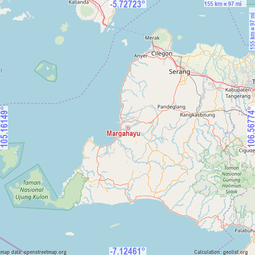
Margahayu GPS coordinates[2]
6° 25' 35.04" South, 105° 51' 52.596" East
| Map corner | latitude | longitude |
|---|---|---|
| Upper-left | -5.72723°, | 105.16149° |
| Center: | -6.4264°, | 105.86461° |
| Lower-right: | -7.12461°, | 106.56774° |
| Map W x H: | 155.4×155.4 km | = 96.6×96.6mi |
| max Lat: | 5.88969° ⇑15% North |
| Margahayu: | -6.4264° |
| min Lat: | ⇓85% South -10.934° |
| min Long | Margahayu | max Long |
| 95.1345° | 105.86461° | 140.9419° |
| W 7.1%⇐ | ⇒92.9% E |
Elevation
Elevation of Margahayu is 15 m = 49 ft, and this is 214.7 m = 704 ft below average elevation for this country.
| Max E: |
3185 m = 10449 ft | 84.2% |
| Avg. | 229.7 m = 754 ft | |
| Margahayu | 15 m = 49 ft | |
Min E: |
-1 m = -3 ft | 15.8% |
See also: Indonesia elevation on elevation.city.
Geographical zone
Margahayu is located in South Torrid zone (between Equator and Tropic of Capricorn). Distance of Equator is 714.5 km =444 mi to North.| Distance of | km | miles | from Margahayu |
|---|---|---|---|
| Equator | 714.5 | 444 | to North |
| Tropic Capricorn | 1891.4 | 1175.3 | to South |
| Antarctic Circle | 6686.6 | 4154.9 | to South |
| South Pole | 9292.5 | 5774.1 | to South |


Nearby cities:
15 places around Margahayu: (largest is in red/bold)
• Carenang Lor
4 km =2.5 mi,  177°
177°
• Cirumput
3.9 km =2.4 mi,  33°
33°
• Kadubadak
4 km =2.5 mi,  9°
9°
• Kadugadung
3.8 km =2.4 mi,  346°
346°
• Kadupayung
3.8 km =2.4 mi,  330°
330°
• Kampungpinggirkali
2.5 km =1.6 mi,  232°
232°
• Kapinango
1.5 km =0.9 mi, 351°
• Kebonjaya
2.4 km =1.5 mi,  212°
212°
• Kubang
2.2 km =1.4 mi,  69°
69°
• Kuluwut Tengah
2.6 km =1.6 mi,  57°
57°
• Montor Timur
3.6 km =2.2 mi,  15°
15°
• Pagelaran
1.1 km =0.7 mi, 228°
• Pangampoan
3.4 km =2.1 mi, 334°
• Surianeun
2.4 km =1.5 mi,  196°
196°
• Tegal
4.3 km =2.7 mi, 56°
Sources, notices
• [Note1] Compared only with cities in Indonesia existing in our database
• [Src1] Map data: © OpenStreetMap contributors (CC-BY-SA)
• [Src2] Other city data from geonames.org with taken over terms of usage.
• [Src3] Geographical zone / Annual Mean Temperature by Robert A. Rohde @ Wikipedia
