Carenang Lor geodata
Carenang Lor (Banten) is a seat of a fourth-order administrative division; located in Indonesia in Asia/Jakarta (GMT+7) time zone. In our database, there are 407 cities with bigger population. Compared to other cities in Indonesia, 84.7% of cities are located further ↓South; 92.9% of cities are located further →East and 90.6% of cities have higher elevation than Carenang Lor. Note1


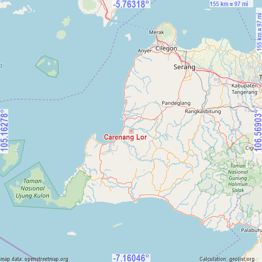
Carenang Lor GPS coordinates[2]
6° 27' 44.28" South, 105° 51' 57.24" East
| Map corner | latitude | longitude |
|---|---|---|
| Upper-left | -5.76318°, | 105.16278° |
| Center: | -6.4623°, | 105.8659° |
| Lower-right: | -7.16046°, | 106.56903° |
| Map W x H: | 155.4×155.4 km | = 96.6×96.6mi |
| max Lat: | 5.88969° ⇑15.3% North |
| Carenang Lor: | -6.4623° |
| min Lat: | ⇓84.7% South -10.934° |
| min Long | Carenang Lor | max Long |
| 95.1345° | 105.8659° | 140.9419° |
| W 7.1%⇐ | ⇒92.9% E |
Elevation
Elevation of Carenang Lor is 10 m = 33 ft, and this is 219.7 m = 721 ft below average elevation for this country.
| Max E: |
3185 m = 10449 ft | 90.6% |
| Avg. | 229.7 m = 754 ft | |
| Carenang Lor | 10 m = 33 ft | |
Min E: |
-1 m = -3 ft | 9.4% |
See also: Indonesia elevation on elevation.city.
Geographical zone
Carenang Lor is located in South Torrid zone (between Equator and Tropic of Capricorn). Distance of Equator is 718.5 km =446.5 mi to North.| Distance of | km | miles | from Carenang Lor |
|---|---|---|---|
| Equator | 718.5 | 446.5 | to North |
| Tropic Capricorn | 1887.4 | 1172.8 | to South |
| Antarctic Circle | 6682.6 | 4152.4 | to South |
| South Pole | 9288.5 | 5771.6 | to South |


Nearby cities:
15 places around Carenang Lor: (largest is in red/bold)
• Cimoyan
2.6 km =1.6 mi,  111°
111°
• Kampungpinggirkali
3.2 km =2 mi,  318°
318°
• Karangtengah
2.3 km =1.4 mi,  79°
79°
• Kebon
1.8 km =1.1 mi,  131°
131°
• Kebonjaya
2.4 km =1.5 mi, 324°
• Kubang
5.1 km =3.2 mi,  21°
21°
• Kubangkampil
4.3 km =2.7 mi,  222°
222°
• Margahayu
4 km =2.5 mi,  357°
357°
• Pagelaran
3.4 km =2.1 mi,  343°
343°
• Pasirgadung Satu
5 km =3.1 mi, 130°
• Patia Kidul
2.7 km =1.7 mi,  195°
195°
• Surianeun
1.9 km =1.2 mi,  334°
334°
• Tegalpapak
5.1 km =3.2 mi,  299°
299°
• Turus
5.2 km =3.2 mi,  160°
160°
• Weru
2.9 km =1.8 mi,  270°
270°
Sources, notices
• [Note1] Compared only with cities in Indonesia existing in our database
• [Src1] Map data: © OpenStreetMap contributors (CC-BY-SA)
• [Src2] Other city data from geonames.org with taken over terms of usage.
• [Src3] Geographical zone / Annual Mean Temperature by Robert A. Rohde @ Wikipedia
