Leuwigede geodata
Leuwigede (Banten) is a seat of a fourth-order administrative division; located in Indonesia in Asia/Jakarta (GMT+7) time zone. In our database, there are 407 cities with bigger population. Compared to other cities in Indonesia, 84.4% of cities are located further ↓South; 93.4% of cities are located further →East and 90.6% of cities have higher elevation than Leuwigede. Note1


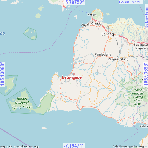
Leuwigede GPS coordinates[2]
6° 29' 47.76" South, 105° 50' 1.68" East
| Map corner | latitude | longitude |
|---|---|---|
| Upper-left | -5.79752°, | 105.13068° |
| Center: | -6.4966°, | 105.8338° |
| Lower-right: | -7.19471°, | 106.53693° |
| Map W x H: | 155.4×155.4 km | = 96.6×96.6mi |
| max Lat: | 5.88969° ⇑15.6% North |
| Leuwigede: | -6.4966° |
| min Lat: | ⇓84.4% South -10.934° |
| min Long | Leuwigede | max Long |
| 95.1345° | 105.8338° | 140.9419° |
| W 6.6%⇐ | ⇒93.4% E |
Elevation
Elevation of Leuwigede is 10 m = 33 ft, and this is 219.7 m = 721 ft below average elevation for this country.
| Max E: |
3185 m = 10449 ft | 90.6% |
| Avg. | 229.7 m = 754 ft | |
| Leuwigede | 10 m = 33 ft | |
Min E: |
-1 m = -3 ft | 9.4% |
See also: Indonesia elevation on elevation.city.
Geographical zone
Leuwigede is located in South Torrid zone (between Equator and Tropic of Capricorn). Distance of Equator is 722.4 km =448.9 mi to North.| Distance of | km | miles | from Leuwigede |
|---|---|---|---|
| Equator | 722.4 | 448.9 | to North |
| Tropic Capricorn | 1883.6 | 1170.4 | to South |
| Antarctic Circle | 6678.8 | 4150 | to South |
| South Pole | 9284.7 | 5769.2 | to South |


Nearby cities:
15 places around Leuwigede: (largest is in red/bold)
• Carenang Lor
5.2 km =3.2 mi,  42°
42°
• Cibungurgardu
3.9 km =2.4 mi,  326°
326°
• Kubangkampil
0.9 km =0.6 mi, 44°
• Neglasari
4.4 km =2.7 mi,  272°
272°
• Panimbang
4.2 km =2.6 mi, 273°
• Paojan
2 km =1.2 mi, 269°
• Pasirkadu
3 km =1.9 mi,  134°
134°
• Patia Kidul
3.1 km =1.9 mi,  67°
67°
• Perdana
3.6 km =2.2 mi,  168°
168°
• Perintis
4.9 km =3 mi,  224°
224°
• Rancahideung
5.3 km =3.3 mi,  163°
163°
• Sidamukti
3.5 km =2.2 mi,  287°
287°
• Teladan
3 km =1.9 mi,  199°
199°
• Turus
5.4 km =3.4 mi,  101°
101°
• Weru
3.9 km =2.4 mi,  8°
8°
Sources, notices
• [Note1] Compared only with cities in Indonesia existing in our database
• [Src1] Map data: © OpenStreetMap contributors (CC-BY-SA)
• [Src2] Other city data from geonames.org with taken over terms of usage.
• [Src3] Geographical zone / Annual Mean Temperature by Robert A. Rohde @ Wikipedia
