Patia Kidul geodata
Patia Kidul (Banten) is a seat of a fourth-order administrative division; located in Indonesia in Asia/Jakarta (GMT+7) time zone. In our database, there are 407 cities with bigger population. Compared to other cities in Indonesia, 84.5% of cities are located further ↓South; 93% of cities are located further →East and 86.4% of cities have higher elevation than Patia Kidul. Note1


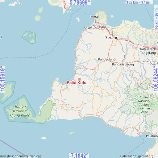
Patia Kidul GPS coordinates[2]
6° 29' 9.888" South, 105° 51' 33.516" East
| Map corner | latitude | longitude |
|---|---|---|
| Upper-left | -5.78699°, | 105.15619° |
| Center: | -6.48608°, | 105.85931° |
| Lower-right: | -7.1842°, | 106.56244° |
| Map W x H: | 155.4×155.4 km | = 96.6×96.6mi |
| max Lat: | 5.88969° ⇑15.5% North |
| Patia Kidul: | -6.48608° |
| min Lat: | ⇓84.5% South -10.934° |
| min Long | Patia Kidul | max Long |
| 95.1345° | 105.85931° | 140.9419° |
| W 7%⇐ | ⇒93% E |
Elevation
Elevation of Patia Kidul is 13 m = 43 ft, and this is 216.7 m = 711 ft below average elevation for this country.
| Max E: |
3185 m = 10449 ft | 86.4% |
| Avg. | 229.7 m = 754 ft | |
| Patia Kidul | 13 m = 43 ft | |
Min E: |
-1 m = -3 ft | 13.6% |
See also: Indonesia elevation on elevation.city.
Geographical zone
Patia Kidul is located in South Torrid zone (between Equator and Tropic of Capricorn). Distance of Equator is 721.2 km =448.1 mi to North.| Distance of | km | miles | from Patia Kidul |
|---|---|---|---|
| Equator | 721.2 | 448.1 | to North |
| Tropic Capricorn | 1884.7 | 1171.1 | to South |
| Antarctic Circle | 6680 | 4150.8 | to South |
| South Pole | 9285.9 | 5770 | to South |


Nearby cities:
15 places around Patia Kidul: (largest is in red/bold)
• Carenang Lor
2.7 km =1.7 mi,  15°
15°
• Cibungurgardu
5.3 km =3.3 mi,  292°
292°
• Cimoyan
3.6 km =2.2 mi,  61°
61°
• Karangtengah
4.3 km =2.7 mi,  44°
44°
• Kebon
2.5 km =1.6 mi, 55°
• Kebonjaya
4.7 km =2.9 mi,  351°
351°
• Kubangkampil
2.3 km =1.4 mi,  256°
256°
• Leuwigede
3.1 km =1.9 mi,  247°
247°
• Paojan
5 km =3.1 mi, 256°
• Pasirgadung Satu
4.6 km =2.9 mi,  98°
98°
• Pasirkadu
3.3 km =2.1 mi,  192°
192°
• Perdana
5.1 km =3.2 mi,  204°
204°
• Surianeun
4.4 km =2.7 mi,  358°
358°
• Turus
3.3 km =2.1 mi,  132°
132°
• Weru
3.5 km =2.2 mi,  319°
319°
Sources, notices
• [Note1] Compared only with cities in Indonesia existing in our database
• [Src1] Map data: © OpenStreetMap contributors (CC-BY-SA)
• [Src2] Other city data from geonames.org with taken over terms of usage.
• [Src3] Geographical zone / Annual Mean Temperature by Robert A. Rohde @ Wikipedia
