Pasirkadu geodata
Pasirkadu (Banten) is a seat of a fourth-order administrative division; located in Indonesia in Asia/Jakarta (GMT+7) time zone. In our database, there are 407 cities with bigger population. Compared to other cities in Indonesia, 84.1% of cities are located further ↓South; 93.1% of cities are located further →East and 83% of cities have higher elevation than Pasirkadu. Note1


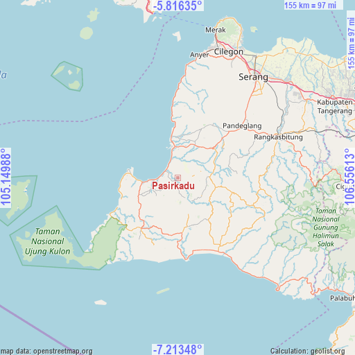
Pasirkadu GPS coordinates[2]
6° 30' 55.44" South, 105° 51' 10.8" East
| Map corner | latitude | longitude |
|---|---|---|
| Upper-left | -5.81635°, | 105.14988° |
| Center: | -6.5154°, | 105.853° |
| Lower-right: | -7.21348°, | 106.55613° |
| Map W x H: | 155.3×155.4 km | = 96.5×96.6mi |
| max Lat: | 5.88969° ⇑15.9% North |
| Pasirkadu: | -6.5154° |
| min Lat: | ⇓84.1% South -10.934° |
| min Long | Pasirkadu | max Long |
| 95.1345° | 105.853° | 140.9419° |
| W 6.9%⇐ | ⇒93.1% E |
Elevation
Elevation of Pasirkadu is 16 m = 52 ft, and this is 213.7 m = 701 ft below average elevation for this country.
| Max E: |
3185 m = 10449 ft | 83% |
| Avg. | 229.7 m = 754 ft | |
| Pasirkadu | 16 m = 52 ft | |
Min E: |
-1 m = -3 ft | 17% |
See also: Indonesia elevation on elevation.city.
Geographical zone
Pasirkadu is located in South Torrid zone (between Equator and Tropic of Capricorn). Distance of Equator is 724.4 km =450.1 mi to North.| Distance of | km | miles | from Pasirkadu |
|---|---|---|---|
| Equator | 724.4 | 450.1 | to North |
| Tropic Capricorn | 1881.5 | 1169.1 | to South |
| Antarctic Circle | 6676.7 | 4148.7 | to South |
| South Pole | 9282.6 | 5767.9 | to South |


Nearby cities:
15 places around Pasirkadu: (largest is in red/bold)
• Awilega
5.7 km =3.5 mi,  185°
185°
• Jambubol
4.1 km =2.5 mi,  147°
147°
• Kalapadua
5.4 km =3.4 mi,  177°
177°
• Kampungbaru
5.6 km =3.5 mi,  110°
110°
• Kebon
5.5 km =3.4 mi,  30°
30°
• Kubangkampil
3.1 km =1.9 mi,  331°
331°
• Leuwigede
3 km =1.9 mi,  314°
314°
• Paojan
4.6 km =2.9 mi,  296°
296°
• Pasirloa
4.8 km =3 mi,  126°
126°
• Patia Kidul
3.3 km =2.1 mi,  12°
12°
• Perdana
2 km =1.2 mi,  225°
225°
• Rancahideung
3.1 km =1.9 mi, 190°
• Seuseupan
5.1 km =3.2 mi, 227°
• Teladan
3.2 km =2 mi,  256°
256°
• Turus
3.3 km =2.1 mi,  72°
72°
Sources, notices
• [Note1] Compared only with cities in Indonesia existing in our database
• [Src1] Map data: © OpenStreetMap contributors (CC-BY-SA)
• [Src2] Other city data from geonames.org with taken over terms of usage.
• [Src3] Geographical zone / Annual Mean Temperature by Robert A. Rohde @ Wikipedia
