Sukacai geodata
Sukacai (Banten) is a seat of a third-order administrative division; located in Indonesia in Asia/Jakarta (GMT+7) time zone. In our database, there are 407 cities with bigger population. Compared to other cities in Indonesia, 86.2% of cities are located further ↓South; 92.9% of cities are located further →East and 58.4% of cities have higher elevation than Sukacai. Note1


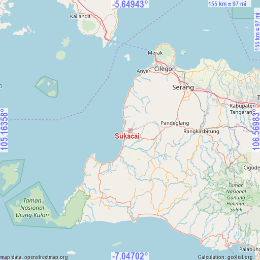
Sukacai GPS coordinates[2]
6° 20' 55.32" South, 105° 52' 0.12" East
| Map corner | latitude | longitude |
|---|---|---|
| Upper-left | -5.64943°, | 105.16358° |
| Center: | -6.3487°, | 105.8667° |
| Lower-right: | -7.04702°, | 106.56983° |
| Map W x H: | 155.4×155.4 km | = 96.6×96.6mi |
| max Lat: | 5.88969° ⇑13.8% North |
| Sukacai: | -6.3487° |
| min Lat: | ⇓86.2% South -10.934° |
| min Long | Sukacai | max Long |
| 95.1345° | 105.8667° | 140.9419° |
| W 7.1%⇐ | ⇒92.9% E |
Elevation
Elevation of Sukacai is 66 m = 217 ft, and this is 163.7 m = 537 ft below average elevation for this country.
| Max E: |
3185 m = 10449 ft | 58.4% |
| Avg. | 229.7 m = 754 ft | |
| Sukacai | 66 m = 217 ft | |
Min E: |
-1 m = -3 ft | 41.6% |
See also: Indonesia elevation on elevation.city.
Geographical zone
Sukacai is located in South Torrid zone (between Equator and Tropic of Capricorn). Distance of Equator is 705.9 km =438.6 mi to North.| Distance of | km | miles | from Sukacai |
|---|---|---|---|
| Equator | 705.9 | 438.6 | to North |
| Tropic Capricorn | 1900 | 1180.6 | to South |
| Antarctic Circle | 6695.3 | 4160.3 | to South |
| South Pole | 9301.2 | 5779.5 | to South |


Nearby cities:
15 places around Sukacai: (largest is in red/bold)
• Banyuresmi
1.7 km =1.1 mi,  118°
118°
• Bogor
1.9 km =1.2 mi,  5°
5°
• Cibango
3.7 km =2.3 mi,  278°
278°
• Jami
2.8 km =1.7 mi,  140°
140°
• Kaducondong
1.3 km =0.8 mi, 277°
• Kaduheuleut
3.7 km =2.3 mi,  68°
68°
• Kadukotok
2.8 km =1.7 mi,  109°
109°
• Padahayu
2.7 km =1.7 mi,  193°
193°
• Pamarayan
3.6 km =2.2 mi,  101°
101°
• Parigi
3.8 km =2.4 mi,  165°
165°
• Picungbera
2.5 km =1.6 mi,  257°
257°
• Sarampu
1.8 km =1.1 mi, 170°
• Sepenmasjid
3 km =1.9 mi,  224°
224°
• Sukacai Tengah
0.4 km =0.2 mi,  206°
206°
• Tenjolahang Timur
1.4 km =0.9 mi,  236°
236°
Sources, notices
• [Note1] Compared only with cities in Indonesia existing in our database
• [Src1] Map data: © OpenStreetMap contributors (CC-BY-SA)
• [Src2] Other city data from geonames.org with taken over terms of usage.
• [Src3] Geographical zone / Annual Mean Temperature by Robert A. Rohde @ Wikipedia
