Pamarayan geodata
Pamarayan (Banten) is a seat of a fourth-order administrative division; located in Indonesia in Asia/Jakarta (GMT+7) time zone. In our database, there are 407 cities with bigger population. Compared to other cities in Indonesia, 86.1% of cities are located further ↓South; 92.4% of cities are located further →East and 54.2% of cities have lower elevation than Pamarayan. Note1


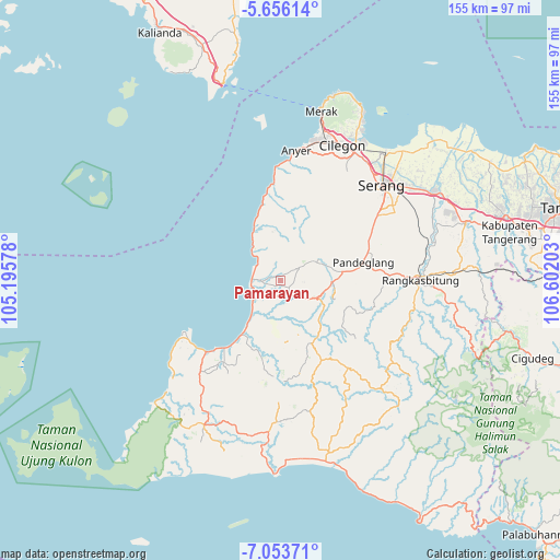
Pamarayan GPS coordinates[2]
6° 21' 19.44" South, 105° 53' 56.04" East
| Map corner | latitude | longitude |
|---|---|---|
| Upper-left | -5.65614°, | 105.19578° |
| Center: | -6.3554°, | 105.8989° |
| Lower-right: | -7.05371°, | 106.60203° |
| Map W x H: | 155.4×155.4 km | = 96.6×96.6mi |
| max Lat: | 5.88969° ⇑13.9% North |
| Pamarayan: | -6.3554° |
| min Lat: | ⇓86.1% South -10.934° |
| min Long | Pamarayan | max Long |
| 95.1345° | 105.8989° | 140.9419° |
| W 7.6%⇐ | ⇒92.4% E |
Elevation
Elevation of Pamarayan is 120 m = 394 ft, and this is 109.7 m = 360 ft below average elevation for this country.
| Max E: |
3185 m = 10449 ft | 45.8% |
| Avg. | 229.7 m = 754 ft | |
| Pamarayan | 120 m = 394 ft | |
Min E: |
-1 m = -3 ft | 54.2% |
See also: Indonesia elevation on elevation.city.
Geographical zone
Pamarayan is located in South Torrid zone (between Equator and Tropic of Capricorn). Distance of Equator is 706.7 km =439.1 mi to North.| Distance of | km | miles | from Pamarayan |
|---|---|---|---|
| Equator | 706.7 | 439.1 | to North |
| Tropic Capricorn | 1899.3 | 1180.2 | to South |
| Antarctic Circle | 6694.5 | 4159.8 | to South |
| South Pole | 9300.4 | 5779 | to South |


Nearby cities:
15 places around Pamarayan: (largest is in red/bold)
• Banyuresmi
2 km =1.2 mi,  268°
268°
• Cigadung
3.6 km =2.2 mi,  47°
47°
• Cikiray
2.7 km =1.7 mi,  175°
175°
• Cukangpanjang
2.7 km =1.7 mi,  26°
26°
• Gonggong
3.6 km =2.2 mi, 182°
• Jami
2.3 km =1.4 mi,  231°
231°
• Jiput
1.3 km =0.8 mi,  12°
12°
• Kaduheuleut
2.1 km =1.3 mi,  357°
357°
• Kadukotok
0.9 km =0.6 mi,  258°
258°
• Kaduranca
3.5 km =2.2 mi,  100°
100°
• Menes
3.1 km =1.9 mi,  135°
135°
• Muruy
1.2 km =0.7 mi,  174°
174°
• Sampangbitung
2.1 km =1.3 mi,  74°
74°
• Sarampu
3.4 km =2.1 mi,  253°
253°
• Sorodot
1.7 km =1.1 mi,  116°
116°
Sources, notices
• [Note1] Compared only with cities in Indonesia existing in our database
• [Src1] Map data: © OpenStreetMap contributors (CC-BY-SA)
• [Src2] Other city data from geonames.org with taken over terms of usage.
• [Src3] Geographical zone / Annual Mean Temperature by Robert A. Rohde @ Wikipedia
