Kalahang geodata
Kalahang (Banten) is a seat of a fourth-order administrative division; located in Indonesia in Asia/Jakarta (GMT+7) time zone. In our database, there are 407 cities with bigger population. Compared to other cities in Indonesia, 86% of cities are located further ↓South; 90.2% of cities are located further →East and 60.1% of cities have lower elevation than Kalahang. Note1


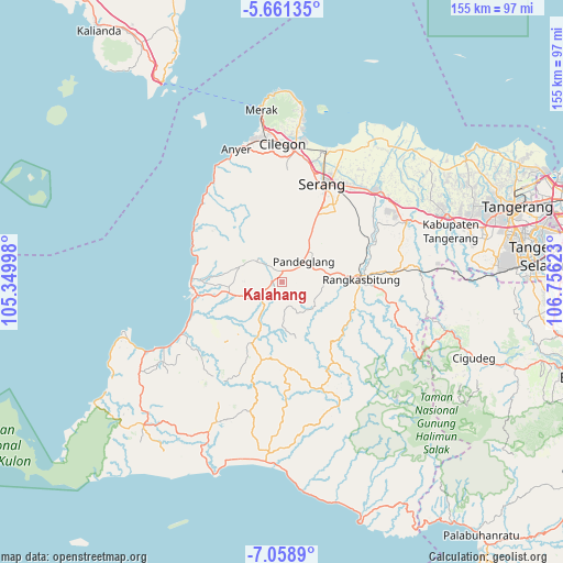
Kalahang GPS coordinates[2]
6° 21' 38.16" South, 106° 3' 11.16" East
| Map corner | latitude | longitude |
|---|---|---|
| Upper-left | -5.66135°, | 105.34998° |
| Center: | -6.3606°, | 106.0531° |
| Lower-right: | -7.0589°, | 106.75623° |
| Map W x H: | 155.4×155.4 km | = 96.6×96.6mi |
| max Lat: | 5.88969° ⇑14% North |
| Kalahang: | -6.3606° |
| min Lat: | ⇓86% South -10.934° |
| min Long | Kalahang | max Long |
| 95.1345° | 106.0531° | 140.9419° |
| W 9.8%⇐ | ⇒90.2% E |
Elevation
Elevation of Kalahang is 165 m = 541 ft, and this is 64.7 m = 212 ft below average elevation for this country.
| Max E: |
3185 m = 10449 ft | 39.9% |
| Avg. | 229.7 m = 754 ft | |
| Kalahang | 165 m = 541 ft | |
Min E: |
-1 m = -3 ft | 60.1% |
See also: Indonesia elevation on elevation.city.
Geographical zone
Kalahang is located in South Torrid zone (between Equator and Tropic of Capricorn). Distance of Equator is 707.2 km =439.4 mi to North.| Distance of | km | miles | from Kalahang |
|---|---|---|---|
| Equator | 707.2 | 439.4 | to North |
| Tropic Capricorn | 1898.7 | 1179.8 | to South |
| Antarctic Circle | 6693.9 | 4159.4 | to South |
| South Pole | 9299.8 | 5778.6 | to South |


Nearby cities:
15 places around Kalahang: (largest is in red/bold)
• Babakan
2.5 km =1.6 mi,  67°
67°
• Batubantar
1.5 km =0.9 mi,  320°
320°
• Cibebek
3.4 km =2.1 mi,  50°
50°
• Cimanuk
3.2 km =2 mi,  304°
304°
• Cimongkor
3.1 km =1.9 mi,  263°
263°
• Curuggaru
2.4 km =1.5 mi,  39°
39°
• Kadulomber
1.7 km =1.1 mi,  231°
231°
• Kukulu
3.2 km =2 mi,  349°
349°
• Panday
1.5 km =0.9 mi,  325°
325°
• Parigi
3.3 km =2.1 mi,  291°
291°
• Pasirawi
3 km =1.9 mi,  190°
190°
• Rocek
0.7 km =0.4 mi, 302°
• Rokoy
3.2 km =2 mi,  15°
15°
• Salinggara
2.9 km =1.8 mi,  97°
97°
• Sekong
2.7 km =1.7 mi, 230°
Sources, notices
• [Note1] Compared only with cities in Indonesia existing in our database
• [Src1] Map data: © OpenStreetMap contributors (CC-BY-SA)
• [Src2] Other city data from geonames.org with taken over terms of usage.
• [Src3] Geographical zone / Annual Mean Temperature by Robert A. Rohde @ Wikipedia
