Sekong geodata
Sekong (Banten) is a seat of a fourth-order administrative division; located in Indonesia in Asia/Jakarta (GMT+7) time zone. In our database, there are 407 cities with bigger population. Compared to other cities in Indonesia, 85.7% of cities are located further ↓South; 90.5% of cities are located further →East and 59.4% of cities have lower elevation than Sekong. Note1


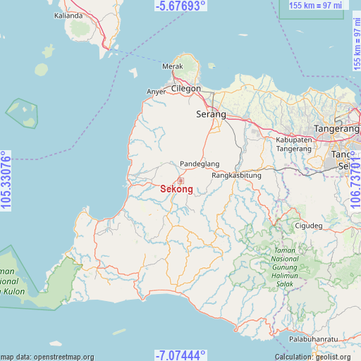
Sekong GPS coordinates[2]
6° 22' 34.176" South, 106° 2' 1.968" East
| Map corner | latitude | longitude |
|---|---|---|
| Upper-left | -5.67693°, | 105.33076° |
| Center: | -6.37616°, | 106.03388° |
| Lower-right: | -7.07444°, | 106.73701° |
| Map W x H: | 155.4×155.4 km | = 96.6×96.6mi |
| max Lat: | 5.88969° ⇑14.3% North |
| Sekong: | -6.37616° |
| min Lat: | ⇓85.7% South -10.934° |
| min Long | Sekong | max Long |
| 95.1345° | 106.03388° | 140.9419° |
| W 9.5%⇐ | ⇒90.5% E |
Elevation
Elevation of Sekong is 157 m = 515 ft, and this is 72.7 m = 239 ft below average elevation for this country.
| Max E: |
3185 m = 10449 ft | 40.6% |
| Avg. | 229.7 m = 754 ft | |
| Sekong | 157 m = 515 ft | |
Min E: |
-1 m = -3 ft | 59.4% |
See also: Indonesia elevation on elevation.city.
Geographical zone
Sekong is located in South Torrid zone (between Equator and Tropic of Capricorn). Distance of Equator is 709 km =440.6 mi to North.| Distance of | km | miles | from Sekong |
|---|---|---|---|
| Equator | 709 | 440.6 | to North |
| Tropic Capricorn | 1897 | 1178.7 | to South |
| Antarctic Circle | 6692.2 | 4158.3 | to South |
| South Pole | 9298.1 | 5777.6 | to South |


Nearby cities:
15 places around Sekong: (largest is in red/bold)
• Batubantar
3.1 km =1.9 mi,  21°
21°
• Cimongkor
1.7 km =1.1 mi,  323°
323°
• Gajahmada
2.4 km =1.5 mi,  263°
263°
• Gobang
3 km =1.9 mi,  279°
279°
• Kadugadung
1.9 km =1.2 mi,  245°
245°
• Kadulomber
1.1 km =0.7 mi,  50°
50°
• Kalahang
2.7 km =1.7 mi, 50°
• Kampungdukuh
2.9 km =1.8 mi,  187°
187°
• Parigi
3.1 km =1.9 mi,  342°
342°
• Parumasan Timur
1.4 km =0.9 mi,  205°
205°
• Pasirawi
2 km =1.2 mi,  127°
127°
• Rancabugel
2.9 km =1.8 mi,  183°
183°
• Rocek
2.6 km =1.6 mi,  35°
35°
• Sobong
2.7 km =1.7 mi, 258°
• Tarikolot
2.3 km =1.4 mi,  308°
308°
Sources, notices
• [Note1] Compared only with cities in Indonesia existing in our database
• [Src1] Map data: © OpenStreetMap contributors (CC-BY-SA)
• [Src2] Other city data from geonames.org with taken over terms of usage.
• [Src3] Geographical zone / Annual Mean Temperature by Robert A. Rohde @ Wikipedia
