Pasirgeleng geodata
Pasirgeleng (Banten) is a seat of a third-order administrative division; located in Indonesia in Asia/Jakarta (GMT+7) time zone. In our database, there are 407 cities with bigger population. Compared to other cities in Indonesia, 76.2% of cities are located further ↓South; 90.9% of cities are located further →East and 79.9% of cities have higher elevation than Pasirgeleng. Note1


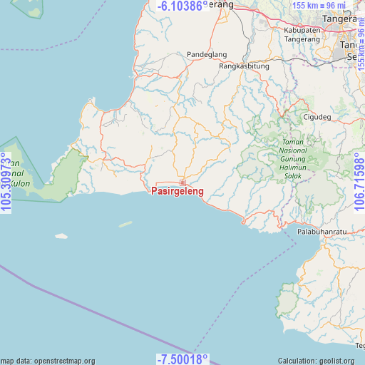
Pasirgeleng GPS coordinates[2]
6° 48' 9.108" South, 106° 0' 46.26" East
| Map corner | latitude | longitude |
|---|---|---|
| Upper-left | -6.10386°, | 105.30973° |
| Center: | -6.80253°, | 106.01285° |
| Lower-right: | -7.50018°, | 106.71598° |
| Map W x H: | 155.3×155.3 km | = 96.5×96.5mi |
| max Lat: | 5.88969° ⇑23.8% North |
| Pasirgeleng: | -6.80253° |
| min Lat: | ⇓76.2% South -10.934° |
| min Long | Pasirgeleng | max Long |
| 95.1345° | 106.01285° | 140.9419° |
| W 9.1%⇐ | ⇒90.9% E |
Elevation
Elevation of Pasirgeleng is 19 m = 62 ft, and this is 210.7 m = 691 ft below average elevation for this country.
| Max E: |
3185 m = 10449 ft | 79.9% |
| Avg. | 229.7 m = 754 ft | |
| Pasirgeleng | 19 m = 62 ft | |
Min E: |
-1 m = -3 ft | 20.1% |
See also: Indonesia elevation on elevation.city.
Geographical zone
Pasirgeleng is located in South Torrid zone (between Equator and Tropic of Capricorn). Distance of Equator is 756.4 km =470 mi to North.| Distance of | km | miles | from Pasirgeleng |
|---|---|---|---|
| Equator | 756.4 | 470 | to North |
| Tropic Capricorn | 1849.5 | 1149.2 | to South |
| Antarctic Circle | 6644.8 | 4128.9 | to South |
| South Pole | 9250.7 | 5748.1 | to South |


Nearby cities:
15 places around Pasirgeleng: (largest is in red/bold)
• Bolang
4.6 km =2.9 mi,  331°
331°
• Citaritih
5 km =3.1 mi,  117°
117°
• Citeureup
3.7 km =2.3 mi,  342°
342°
• Daleum
7.4 km =4.6 mi,  319°
319°
• Jatiraya
0.8 km =0.5 mi,  140°
140°
• Kadujajar
6.2 km =3.9 mi,  13°
13°
• Kandang Timur
0.8 km =0.5 mi,  256°
256°
• Kandangsapi
6.9 km =4.3 mi,  15°
15°
• Malingping
2.7 km =1.7 mi, 11°
• Pagelaran
3.3 km =2.1 mi, 115°
• Pagenggang Selatan
6.7 km =4.2 mi, 334°
• Pasirhaur
2.9 km =1.8 mi, 8°
• Sanghiang
4.3 km =2.7 mi, 344°
• Sukamaju
5.4 km =3.4 mi,  50°
50°
• Sukaraja
2.2 km =1.4 mi,  37°
37°
Sources, notices
• [Note1] Compared only with cities in Indonesia existing in our database
• [Src1] Map data: © OpenStreetMap contributors (CC-BY-SA)
• [Src2] Other city data from geonames.org with taken over terms of usage.
• [Src3] Geographical zone / Annual Mean Temperature by Robert A. Rohde @ Wikipedia
