Kertajadi geodata
Kertajadi (West Java) is a seat of a third-order administrative division; located in Indonesia in Asia/Jakarta (GMT+7) time zone. In our database, there are 407 cities with bigger population. Compared to other cities in Indonesia, 55.6% of cities are located further ↑North; 84.3% of cities are located further →East and 71.9% of cities have higher elevation than Kertajadi. Note1


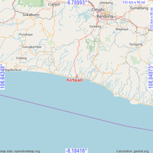
Kertajadi GPS coordinates[2]
7° 29' 15.36" South, 107° 20' 47.76" East
| Map corner | latitude | longitude |
|---|---|---|
| Upper-left | -6.78993°, | 106.64348° |
| Center: | -7.4876°, | 107.3466° |
| Lower-right: | -8.18416°, | 108.04973° |
| Map W x H: | 155×155 km | = 96.3×96.3mi |
| max Lat: | 5.88969° ⇑55.6% North |
| Kertajadi: | -7.4876° |
| min Lat: | ⇓44.4% South -10.934° |
| min Long | Kertajadi | max Long |
| 95.1345° | 107.3466° | 140.9419° |
| W 15.7%⇐ | ⇒84.3% E |
Elevation
Elevation of Kertajadi is 29 m = 95 ft, and this is 200.7 m = 658 ft below average elevation for this country.
| Max E: |
3185 m = 10449 ft | 71.9% |
| Avg. | 229.7 m = 754 ft | |
| Kertajadi | 29 m = 95 ft | |
Min E: |
-1 m = -3 ft | 28.1% |
See also: Indonesia elevation on elevation.city.
Geographical zone
Kertajadi is located in South Torrid zone (between Equator and Tropic of Capricorn). Distance of Equator is 832.5 km =517.3 mi to North.| Distance of | km | miles | from Kertajadi |
|---|---|---|---|
| Equator | 832.5 | 517.3 | to North |
| Tropic Capricorn | 1773.4 | 1101.9 | to South |
| Antarctic Circle | 6568.6 | 4081.5 | to South |
| South Pole | 9174.5 | 5700.8 | to South |


Nearby cities:
15 places around Kertajadi: (largest is in red/bold)
• Bantarmunding
9.1 km =5.7 mi,  84°
84°
• Baranti
12.1 km =7.5 mi,  44°
44°
• Ciawitali
7.6 km =4.7 mi,  18°
18°
• Cikamurang
11.4 km =7.1 mi,  271°
271°
• Cikarang
13.6 km =8.5 mi,  59°
59°
• Cikole
7.7 km =4.8 mi, 268°
• Ciparay
13 km =8.1 mi,  356°
356°
• Gunungbatu
10.9 km =6.8 mi,  322°
322°
• Indralayang
15.2 km =9.4 mi,  93°
93°
• Karangpawitan
7.8 km =4.8 mi,  31°
31°
• Kebonkopi
10 km =6.2 mi, 271°
• Kendalngupuk
11.2 km =7 mi,  295°
295°
• Malati
14.3 km =8.9 mi,  348°
348°
• Puncakwangi
7.3 km =4.5 mi, 76°
• Wangunjaya
9.8 km =6.1 mi, 349°
Sources, notices
• [Note1] Compared only with cities in Indonesia existing in our database
• [Src1] Map data: © OpenStreetMap contributors (CC-BY-SA)
• [Src2] Other city data from geonames.org with taken over terms of usage.
• [Src3] Geographical zone / Annual Mean Temperature by Robert A. Rohde @ Wikipedia
