Gintungsari geodata
Gintungsari (West Java) is a seat of a fourth-order administrative division; located in Indonesia in Asia/Jakarta (GMT+7) time zone. In our database, there are 407 cities with bigger population. Compared to other cities in Indonesia, 57.5% of cities are located further ↓South; 85.3% of cities are located further →East and 94% of cities have lower elevation than Gintungsari. Note1


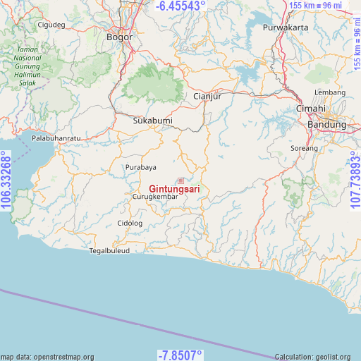
Gintungsari GPS coordinates[2]
7° 9' 12.96" South, 107° 2' 8.88" East
| Map corner | latitude | longitude |
|---|---|---|
| Upper-left | -6.45543°, | 106.33268° |
| Center: | -7.1536°, | 107.0358° |
| Lower-right: | -7.8507°, | 107.73893° |
| Map W x H: | 155.1×155.1 km | = 96.4×96.4mi |
| max Lat: | 5.88969° ⇑42.5% North |
| Gintungsari: | -7.1536° |
| min Lat: | ⇓57.5% South -10.934° |
| min Long | Gintungsari | max Long |
| 95.1345° | 107.0358° | 140.9419° |
| W 14.7%⇐ | ⇒85.3% E |
Elevation
Elevation of Gintungsari is 766 m = 2513 ft, and this is 536.3 m = 1760 ft above average elevation for this country.
| Max E: |
3185 m = 10449 ft | 6% |
| Gintungsari | 766 m 2513 ft | |
| Avg. | 229.7 m = 754 ft | |
Min E: |
-1 m = -3 ft | 94% |
See also: Indonesia elevation on elevation.city.
Geographical zone
Gintungsari is located in South Torrid zone (between Equator and Tropic of Capricorn). Distance of Equator is 795.4 km =494.2 mi to North.| Distance of | km | miles | from Gintungsari |
|---|---|---|---|
| Equator | 795.4 | 494.2 | to North |
| Tropic Capricorn | 1810.5 | 1125 | to South |
| Antarctic Circle | 6605.8 | 4104.7 | to South |
| South Pole | 9211.7 | 5723.9 | to South |


Nearby cities:
15 places around Gintungsari: (largest is in red/bold)
• Babakanbandung
6.5 km =4 mi,  351°
351°
• Cibogo Dua
6.9 km =4.3 mi,  213°
213°
• Ciduren
6.1 km =3.8 mi,  134°
134°
• Ciguha Tengah
5.2 km =3.2 mi,  24°
24°
• Cintasari
8.1 km =5 mi,  180°
180°
• Ciodeng
8 km =5 mi,  55°
55°
• Dampit Satu
5.1 km =3.2 mi,  264°
264°
• Kalapanunggal
7.6 km =4.7 mi, 206°
• Kalibaru
8.7 km =5.4 mi,  4°
4°
• Kampungtengah
5.3 km =3.3 mi,  78°
78°
• Simpang
3.9 km =2.4 mi,  291°
291°
• Sukamahi Satu
2.8 km =1.7 mi, 353°
• Sukamulya
8.2 km =5.1 mi,  115°
115°
• Sukasari
4.7 km =2.9 mi,  153°
153°
• Warungawi
4.2 km =2.6 mi,  193°
193°
Sources, notices
• [Note1] Compared only with cities in Indonesia existing in our database
• [Src1] Map data: © OpenStreetMap contributors (CC-BY-SA)
• [Src2] Other city data from geonames.org with taken over terms of usage.
• [Src3] Geographical zone / Annual Mean Temperature by Robert A. Rohde @ Wikipedia
