Simpang geodata
Simpang (West Java) is a seat of a fourth-order administrative division; located in Indonesia in Asia/Jakarta (GMT+7) time zone. In our database, there are 407 cities with bigger population. Compared to other cities in Indonesia, 58.1% of cities are located further ↓South; 85.5% of cities are located further →East and 93.8% of cities have lower elevation than Simpang. Note1


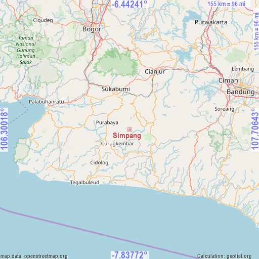
Simpang GPS coordinates[2]
7° 8' 26.16" South, 107° 0' 11.88" East
| Map corner | latitude | longitude |
|---|---|---|
| Upper-left | -6.44241°, | 106.30018° |
| Center: | -7.1406°, | 107.0033° |
| Lower-right: | -7.83772°, | 107.70643° |
| Map W x H: | 155.1×155.1 km | = 96.4×96.4mi |
| max Lat: | 5.88969° ⇑41.9% North |
| Simpang: | -7.1406° |
| min Lat: | ⇓58.1% South -10.934° |
| min Long | Simpang | max Long |
| 95.1345° | 107.0033° | 140.9419° |
| W 14.5%⇐ | ⇒85.5% E |
Elevation
Elevation of Simpang is 759 m = 2490 ft, and this is 529.3 m = 1737 ft above average elevation for this country.
| Max E: |
3185 m = 10449 ft | 6.2% |
| Simpang | 759 m 2490 ft | |
| Avg. | 229.7 m = 754 ft | |
Min E: |
-1 m = -3 ft | 93.8% |
See also: Indonesia elevation on elevation.city.
Geographical zone
Simpang is located in South Torrid zone (between Equator and Tropic of Capricorn). Distance of Equator is 794 km =493.4 mi to North.| Distance of | km | miles | from Simpang |
|---|---|---|---|
| Equator | 794 | 493.4 | to North |
| Tropic Capricorn | 1812 | 1125.9 | to South |
| Antarctic Circle | 6607.2 | 4105.5 | to South |
| South Pole | 9213.1 | 5724.8 | to South |


Nearby cities:
15 places around Simpang: (largest is in red/bold)
• Babakanbandung
5.6 km =3.5 mi,  27°
27°
• Cibogo Dua
7.2 km =4.5 mi,  181°
181°
• Ciguha Tengah
6.6 km =4.1 mi,  60°
60°
• Dampit Satu
2.4 km =1.5 mi,  216°
216°
• Gintungsari
3.9 km =2.4 mi,  111°
111°
• Kalapanunggal
8.2 km =5.1 mi, 178°
• Kalibaru
8.4 km =5.2 mi, 31°
• Pasirawi
7.5 km =4.7 mi,  310°
310°
• Puncakmanis
8.5 km =5.3 mi,  211°
211°
• Sindangraja
8.5 km =5.3 mi,  295°
295°
• Sukamahi Satu
3.5 km =2.2 mi,  68°
68°
• Sukamaju
6.9 km =4.3 mi,  239°
239°
• Sukasari
8 km =5 mi,  135°
135°
• Tanahbeureum
5.7 km =3.5 mi, 310°
• Warungawi
6.1 km =3.8 mi,  154°
154°
Sources, notices
• [Note1] Compared only with cities in Indonesia existing in our database
• [Src1] Map data: © OpenStreetMap contributors (CC-BY-SA)
• [Src2] Other city data from geonames.org with taken over terms of usage.
• [Src3] Geographical zone / Annual Mean Temperature by Robert A. Rohde @ Wikipedia
