Babakanbandung geodata
Babakanbandung (West Java) is a seat of a fourth-order administrative division; located in Indonesia in Asia/Jakarta (GMT+7) time zone. In our database, there are 407 cities with bigger population. Compared to other cities in Indonesia, 60.4% of cities are located further ↓South; 85.4% of cities are located further →East and 97.4% of cities have lower elevation than Babakanbandung. Note1


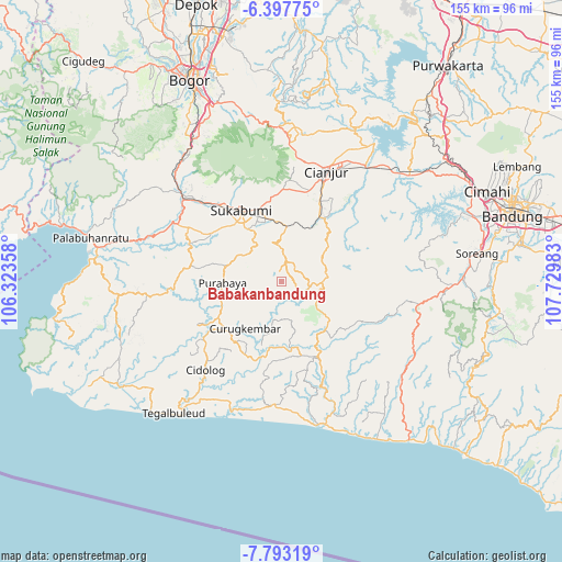
Babakanbandung GPS coordinates[2]
7° 5' 45.6" South, 107° 1' 36.12" East
| Map corner | latitude | longitude |
|---|---|---|
| Upper-left | -6.39775°, | 106.32358° |
| Center: | -7.096°, | 107.0267° |
| Lower-right: | -7.79319°, | 107.72983° |
| Map W x H: | 155.2×155.2 km | = 96.4×96.4mi |
| max Lat: | 5.88969° ⇑39.6% North |
| Babakanbandung: | -7.096° |
| min Lat: | ⇓60.4% South -10.934° |
| min Long | Babakanbandung | max Long |
| 95.1345° | 107.0267° | 140.9419° |
| W 14.6%⇐ | ⇒85.4% E |
Elevation
Elevation of Babakanbandung is 980 m = 3215 ft, and this is 750.3 m = 2462 ft above average elevation for this country.
| Max E: |
3185 m = 10449 ft | 2.6% |
| Babakanbandung | 980 m 3215 ft | |
| Avg. | 229.7 m = 754 ft | |
Min E: |
-1 m = -3 ft | 97.4% |
See also: Indonesia elevation on elevation.city.
Geographical zone
Babakanbandung is located in South Torrid zone (between Equator and Tropic of Capricorn). Distance of Equator is 789 km =490.3 mi to North.| Distance of | km | miles | from Babakanbandung |
|---|---|---|---|
| Equator | 789 | 490.3 | to North |
| Tropic Capricorn | 1816.9 | 1129 | to South |
| Antarctic Circle | 6612.2 | 4108.6 | to South |
| South Pole | 9218.1 | 5727.9 | to South |


Nearby cities:
15 places around Babakanbandung: (largest is in red/bold)
• Babakanlapang
5 km =3.1 mi,  47°
47°
• Bungbangsari
6.3 km =3.9 mi,  303°
303°
• Ciguha Tengah
3.6 km =2.2 mi,  117°
117°
• Ciodeng
7.9 km =4.9 mi,  103°
103°
• Dampit Satu
8 km =5 mi,  210°
210°
• Gintungsari
6.5 km =4 mi,  171°
171°
• Kalibaru
2.8 km =1.7 mi,  38°
38°
• Kampungtengah
8.1 km =5 mi,  130°
130°
• Mekarjaya
7.9 km =4.9 mi,  358°
358°
• Pasirawi
8.2 km =5.1 mi,  269°
269°
• Pasirhuni
8.8 km =5.5 mi,  331°
331°
• Simpang
5.6 km =3.5 mi, 207°
• Sukamahi Satu
3.7 km =2.3 mi, 169°
• Takokak
5.6 km =3.5 mi, 332°
• Tanahbeureum
7 km =4.3 mi,  259°
259°
Sources, notices
• [Note1] Compared only with cities in Indonesia existing in our database
• [Src1] Map data: © OpenStreetMap contributors (CC-BY-SA)
• [Src2] Other city data from geonames.org with taken over terms of usage.
• [Src3] Geographical zone / Annual Mean Temperature by Robert A. Rohde @ Wikipedia
