Gunungkawung geodata
Gunungkawung (West Java) is a seat of a fourth-order administrative division; located in Indonesia in Asia/Jakarta (GMT+7) time zone. In our database, there are 407 cities with bigger population. Compared to other cities in Indonesia, 50.7% of cities are located further ↑North; 77.8% of cities are located further →East and 79.2% of cities have lower elevation than Gunungkawung. Note1


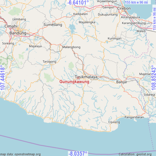
Gunungkawung GPS coordinates[2]
7° 20' 20.04" South, 108° 8' 57.48" East
| Map corner | latitude | longitude |
|---|---|---|
| Upper-left | -6.64101°, | 107.44618° |
| Center: | -7.3389°, | 108.1493° |
| Lower-right: | -8.0357°, | 108.85243° |
| Map W x H: | 155.1×155.1 km | = 96.4×96.4mi |
| max Lat: | 5.88969° ⇑50.7% North |
| Gunungkawung: | -7.3389° |
| min Lat: | ⇓49.3% South -10.934° |
| min Long | Gunungkawung | max Long |
| 95.1345° | 108.1493° | 140.9419° |
| W 22.2%⇐ | ⇒77.8% E |
Elevation
Elevation of Gunungkawung is 418 m = 1371 ft, and this is 188.3 m = 618 ft above average elevation for this country.
| Max E: |
3185 m = 10449 ft | 20.8% |
| Gunungkawung | 418 m 1371 ft | |
| Avg. | 229.7 m = 754 ft | |
Min E: |
-1 m = -3 ft | 79.2% |
See also: Indonesia elevation on elevation.city.
Geographical zone
Gunungkawung is located in South Torrid zone (between Equator and Tropic of Capricorn). Distance of Equator is 816 km =507 mi to North.| Distance of | km | miles | from Gunungkawung |
|---|---|---|---|
| Equator | 816 | 507 | to North |
| Tropic Capricorn | 1789.9 | 1112.2 | to South |
| Antarctic Circle | 6585.2 | 4091.9 | to South |
| South Pole | 9191.1 | 5711.1 | to South |


Nearby cities:
15 places around Gunungkawung: (largest is in red/bold)
• Banjarsari
2.7 km =1.7 mi,  351°
351°
• Cidamar
1.4 km =0.9 mi,  236°
236°
• Cimanglid
4 km =2.5 mi,  260°
260°
• Cisaro
3.4 km =2.1 mi, 242°
• Golacir
2.8 km =1.7 mi,  291°
291°
• Gunungangka
1.7 km =1.1 mi,  105°
105°
• Gunungbatara
2.4 km =1.5 mi,  336°
336°
• Pagaden
2.2 km =1.4 mi,  21°
21°
• Pasirangin
3.6 km =2.2 mi,  43°
43°
• Pasiripis
2 km =1.2 mi, 113°
• Rancakukun
2.8 km =1.7 mi,  103°
103°
• Sindangsari
3.7 km =2.3 mi,  158°
158°
• Sudimara
4.1 km =2.5 mi,  130°
130°
• Sukamulya
4 km =2.5 mi,  234°
234°
• Tabrik
2.8 km =1.7 mi,  208°
208°
Sources, notices
• [Note1] Compared only with cities in Indonesia existing in our database
• [Src1] Map data: © OpenStreetMap contributors (CC-BY-SA)
• [Src2] Other city data from geonames.org with taken over terms of usage.
• [Src3] Geographical zone / Annual Mean Temperature by Robert A. Rohde @ Wikipedia
