Legok geodata
Legok (Central Java) is a seat of a fourth-order administrative division; located in Indonesia in Asia/Jakarta (GMT+7) time zone. In our database, there are 407 cities with bigger population. Compared to other cities in Indonesia, 78.4% of cities are located further ↓South; 62.7% of cities are located further →East and 83% of cities have higher elevation than Legok. Note1


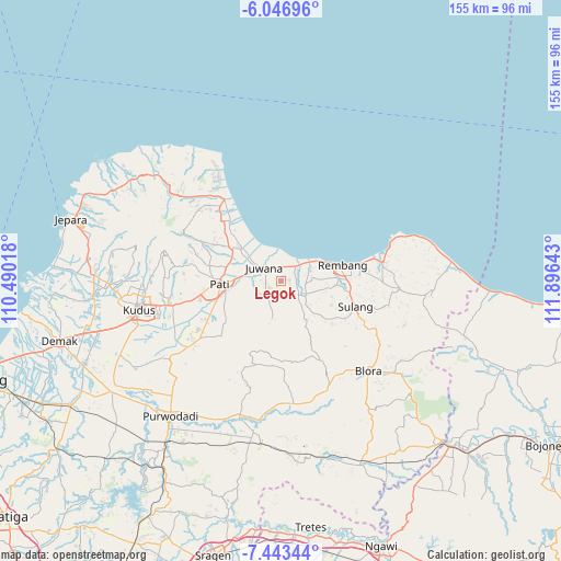
Legok GPS coordinates[2]
6° 44' 44.52" South, 111° 11' 35.88" East
| Map corner | latitude | longitude |
|---|---|---|
| Upper-left | -6.04696°, | 110.49018° |
| Center: | -6.7457°, | 111.1933° |
| Lower-right: | -7.44344°, | 111.89643° |
| Map W x H: | 155.3×155.3 km | = 96.5×96.5mi |
| max Lat: | 5.88969° ⇑21.6% North |
| Legok: | -6.7457° |
| min Lat: | ⇓78.4% South -10.934° |
| min Long | Legok | max Long |
| 95.1345° | 111.1933° | 140.9419° |
| W 37.3%⇐ | ⇒62.7% E |
Elevation
Elevation of Legok is 16 m = 52 ft, and this is 213.7 m = 701 ft below average elevation for this country.
| Max E: |
3185 m = 10449 ft | 83% |
| Avg. | 229.7 m = 754 ft | |
| Legok | 16 m = 52 ft | |
Min E: |
-1 m = -3 ft | 17% |
See also: Indonesia elevation on elevation.city.
Geographical zone
Legok is located in South Torrid zone (between Equator and Tropic of Capricorn). Distance of Equator is 750.1 km =466.1 mi to North.| Distance of | km | miles | from Legok |
|---|---|---|---|
| Equator | 750.1 | 466.1 | to North |
| Tropic Capricorn | 1855.9 | 1153.2 | to South |
| Antarctic Circle | 6651.1 | 4132.8 | to South |
| South Pole | 9257 | 5752 | to South |


Nearby cities:
15 places around Legok: (largest is in red/bold)
• Blingi
3.3 km =2.1 mi,  195°
195°
• Bulumulyo
1.6 km =1 mi,  24°
24°
• Jakenan
3.7 km =2.3 mi,  240°
240°
• Kebonturi
1.8 km =1.1 mi,  214°
214°
• Ketip
3.3 km =2.1 mi,  296°
296°
• Ketitang Wetan
3.9 km =2.4 mi,  354°
354°
• Klayusiwalan
2.8 km =1.7 mi, 15°
• Lundo
3 km =1.9 mi,  162°
162°
• Ngening
3.1 km =1.9 mi,  332°
332°
• Pagak Kulon
2.8 km =1.7 mi,  119°
119°
• Plalangan
3.8 km =2.4 mi,  105°
105°
• Plosojenar
1.8 km =1.1 mi,  258°
258°
• Sobo
3.4 km =2.1 mi,  135°
135°
• Tlogomojo
2.3 km =1.4 mi,  278°
278°
• Trolu
2.4 km =1.5 mi,  78°
78°
Sources, notices
• [Note1] Compared only with cities in Indonesia existing in our database
• [Src1] Map data: © OpenStreetMap contributors (CC-BY-SA)
• [Src2] Other city data from geonames.org with taken over terms of usage.
• [Src3] Geographical zone / Annual Mean Temperature by Robert A. Rohde @ Wikipedia
