Pengkol geodata
Pengkol (Central Java) is a seat of a fourth-order administrative division; located in Indonesia in Asia/Jakarta (GMT+7) time zone. In our database, there are 407 cities with bigger population. Compared to other cities in Indonesia, 78.9% of cities are located further ↓South; 61.8% of cities are located further →East and 77.1% of cities have higher elevation than Pengkol. Note1


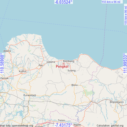
Pengkol GPS coordinates[2]
6° 44' 2.4" South, 111° 17' 31.92" East
| Map corner | latitude | longitude |
|---|---|---|
| Upper-left | -6.03524°, | 110.58908° |
| Center: | -6.734°, | 111.2922° |
| Lower-right: | -7.43175°, | 111.99533° |
| Map W x H: | 155.3×155.3 km | = 96.5×96.5mi |
| max Lat: | 5.88969° ⇑21.1% North |
| Pengkol: | -6.734° |
| min Lat: | ⇓78.9% South -10.934° |
| min Long | Pengkol | max Long |
| 95.1345° | 111.2922° | 140.9419° |
| W 38.2%⇐ | ⇒61.8% E |
Elevation
Elevation of Pengkol is 22 m = 72 ft, and this is 207.7 m = 681 ft below average elevation for this country.
| Max E: |
3185 m = 10449 ft | 77.1% |
| Avg. | 229.7 m = 754 ft | |
| Pengkol | 22 m = 72 ft | |
Min E: |
-1 m = -3 ft | 22.9% |
See also: Indonesia elevation on elevation.city.
Geographical zone
Pengkol is located in South Torrid zone (between Equator and Tropic of Capricorn). Distance of Equator is 748.8 km =465.3 mi to North.| Distance of | km | miles | from Pengkol |
|---|---|---|---|
| Equator | 748.8 | 465.3 | to North |
| Tropic Capricorn | 1857.2 | 1154 | to South |
| Antarctic Circle | 6652.4 | 4133.6 | to South |
| South Pole | 9258.3 | 5752.8 | to South |


Nearby cities:
15 places around Pengkol: (largest is in red/bold)
• Babadan
1.4 km =0.9 mi,  12°
12°
• Banggi
1.4 km =0.9 mi,  186°
186°
• Bangker
4.1 km =2.5 mi,  87°
87°
• Dresi Kulon
3.6 km =2.2 mi,  314°
314°
• Dresi Wetan
2.9 km =1.8 mi,  323°
323°
• Gingsir
2.8 km =1.7 mi,  251°
251°
• Grawan
3.7 km =2.3 mi,  182°
182°
• Karangsekar
2.6 km =1.6 mi, 8°
• Kuangsan
1.5 km =0.9 mi,  149°
149°
• Legok
3.8 km =2.4 mi,  142°
142°
• Mojogajeh
3.7 km =2.3 mi,  206°
206°
• Pentil
2.5 km =1.6 mi, 136°
• Sambiyan
2.5 km =1.6 mi,  276°
276°
• Tlogotunggal
2.6 km =1.6 mi,  168°
168°
• Waru Selatan
4 km =2.5 mi,  63°
63°
Sources, notices
• [Note1] Compared only with cities in Indonesia existing in our database
• [Src1] Map data: © OpenStreetMap contributors (CC-BY-SA)
• [Src2] Other city data from geonames.org with taken over terms of usage.
• [Src3] Geographical zone / Annual Mean Temperature by Robert A. Rohde @ Wikipedia
