Kebon geodata
Kebon (Central Java) is a seat of a fourth-order administrative division; located in Indonesia in Asia/Jakarta (GMT+7) time zone. In our database, there are 407 cities with bigger population. Compared to other cities in Indonesia, 78.2% of cities are located further ↓South; 61% of cities are located further →East and 68% of cities have higher elevation than Kebon. Note1


Kebon GPS coordinates[2]
6° 44' 59.64" South, 111° 21' 4.68" East
| Map corner | latitude | longitude |
|---|---|---|
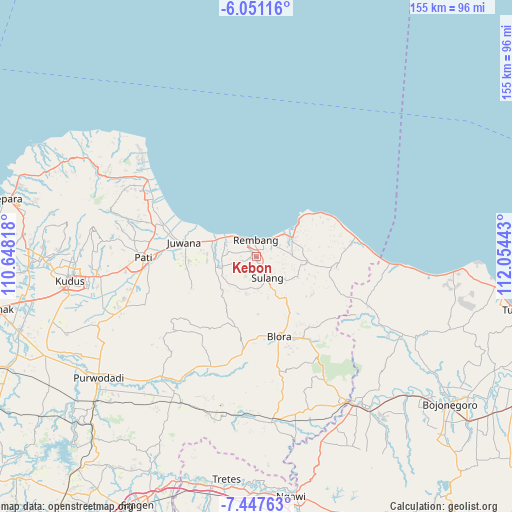
| Upper-left | -6.05116°, | 110.64818° |
| Center: | -6.7499°, | 111.3513° |
| Lower-right: | -7.44763°, | 112.05443° |
| Map W x H: | 155.3×155.3 km | = 96.5×96.5mi |
| max Lat: | 5.88969° ⇑21.8% North |
| Kebon: | -6.7499° |
| min Lat: | ⇓78.2% South -10.934° |
| min Long | Kebon | max Long |
| 95.1345° | 111.3513° | 140.9419° |
| W 39%⇐ | ⇒61% E |
Elevation
Elevation of Kebon is 36 m = 118 ft, and this is 193.7 m = 635 ft below average elevation for this country.
| Max E: |
3185 m = 10449 ft | 68% |
| Avg. | 229.7 m = 754 ft | |
| Kebon | 36 m = 118 ft | |
Min E: |
-1 m = -3 ft | 32% |
See also: Indonesia elevation on elevation.city.
Geographical zone
Kebon is located in South Torrid zone (between Equator and Tropic of Capricorn). Distance of Equator is 750.5 km =466.3 mi to North.| Distance of | km | miles | from Kebon |
|---|---|---|---|
| Equator | 750.5 | 466.3 | to North |
| Tropic Capricorn | 1855.4 | 1152.9 | to South |
| Antarctic Circle | 6650.7 | 4132.6 | to South |
| South Pole | 9256.5 | 5751.7 | to South |


Nearby cities:
15 places around Kebon: (largest is in red/bold)
• Bangker
3.2 km =2 mi,  308°
308°
• Bogorame
1.9 km =1.2 mi,  161°
161°
• Kebonagung
0.8 km =0.5 mi,  249°
249°
• Ketanggi
2.4 km =1.5 mi,  327°
327°
• Krajan Landoh
2.6 km =1.6 mi,  124°
124°
• Lojigawaran
1.2 km =0.7 mi,  43°
43°
• Mondoteko
1.7 km =1.1 mi,  336°
336°
• Ngadem
2 km =1.2 mi, 310°
• Ngotet Kidul
2.2 km =1.4 mi,  19°
19°
• Nrondo
2.1 km =1.3 mi,  58°
58°
• Pragu
1.7 km =1.1 mi,  260°
260°
• Pranti
1.3 km =0.8 mi, 161°
• Seren Barat
2.4 km =1.5 mi, 245°
• Trambalan
3.2 km =2 mi, 249°
• Weton
2.8 km =1.7 mi,  47°
47°
Sources, notices
• [Note1] Compared only with cities in Indonesia existing in our database
• [Src1] Map data: © OpenStreetMap contributors (CC-BY-SA)
• [Src2] Other city data from geonames.org with taken over terms of usage.
• [Src3] Geographical zone / Annual Mean Temperature by Robert A. Rohde @ Wikipedia
