Legok geodata
Legok (Central Java) is a seat of a fourth-order administrative division; located in Indonesia in Asia/Jakarta (GMT+7) time zone. In our database, there are 407 cities with bigger population. Compared to other cities in Indonesia, 77.8% of cities are located further ↓South; 61.5% of cities are located further →East and 66.1% of cities have higher elevation than Legok. Note1


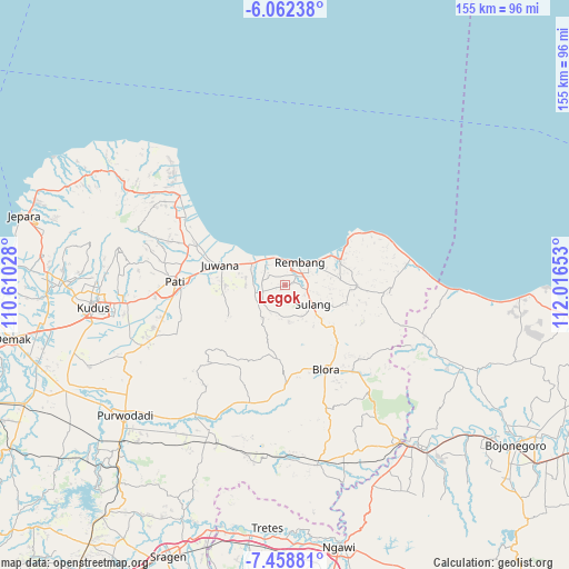
Legok GPS coordinates[2]
6° 45' 39.96" South, 111° 18' 48.24" East
| Map corner | latitude | longitude |
|---|---|---|
| Upper-left | -6.06238°, | 110.61028° |
| Center: | -6.7611°, | 111.3134° |
| Lower-right: | -7.45881°, | 112.01653° |
| Map W x H: | 155.3×155.3 km | = 96.5×96.5mi |
| max Lat: | 5.88969° ⇑22.2% North |
| Legok: | -6.7611° |
| min Lat: | ⇓77.8% South -10.934° |
| min Long | Legok | max Long |
| 95.1345° | 111.3134° | 140.9419° |
| W 38.5%⇐ | ⇒61.5% E |
Elevation
Elevation of Legok is 40 m = 131 ft, and this is 189.7 m = 622 ft below average elevation for this country.
| Max E: |
3185 m = 10449 ft | 66.1% |
| Avg. | 229.7 m = 754 ft | |
| Legok | 40 m = 131 ft | |
Min E: |
-1 m = -3 ft | 33.9% |
See also: Indonesia elevation on elevation.city.
Geographical zone
Legok is located in South Torrid zone (between Equator and Tropic of Capricorn). Distance of Equator is 751.8 km =467.1 mi to North.| Distance of | km | miles | from Legok |
|---|---|---|---|
| Equator | 751.8 | 467.1 | to North |
| Tropic Capricorn | 1854.2 | 1152.1 | to South |
| Antarctic Circle | 6649.4 | 4131.7 | to South |
| South Pole | 9255.3 | 5751 | to South |


Nearby cities:
15 places around Legok: (largest is in red/bold)
• Banggi
3 km =1.9 mi,  302°
302°
• Bangker
3.7 km =2.3 mi,  27°
27°
• Bulak
2.1 km =1.3 mi,  225°
225°
• Grawan
2.6 km =1.6 mi,  254°
254°
• Kebonagung
3.6 km =2.2 mi,  74°
74°
• Kuangsan
2.3 km =1.4 mi,  317°
317°
• Mojogajeh
4 km =2.5 mi,  265°
265°
• Ngadem
3.7 km =2.3 mi,  46°
46°
• Pengkol
3.8 km =2.4 mi, 322°
• Pentil
1.4 km =0.9 mi,  333°
333°
• Pragu
2.7 km =1.7 mi, 69°
• Seren Barat
2 km =1.2 mi,  83°
83°
• Sudo
3.2 km =2 mi,  158°
158°
• Tlogotunggal
1.9 km =1.2 mi,  284°
284°
• Trambalan
1.2 km =0.7 mi, 82°
Sources, notices
• [Note1] Compared only with cities in Indonesia existing in our database
• [Src1] Map data: © OpenStreetMap contributors (CC-BY-SA)
• [Src2] Other city data from geonames.org with taken over terms of usage.
• [Src3] Geographical zone / Annual Mean Temperature by Robert A. Rohde @ Wikipedia
