Ngrojo geodata
Ngrojo (Central Java) is a seat of a fourth-order administrative division; located in Indonesia in Asia/Jakarta (GMT+7) time zone. In our database, there are 407 cities with bigger population. Compared to other cities in Indonesia, 75.3% of cities are located further ↓South; 61% of cities are located further →East and 57.9% of cities have higher elevation than Ngrojo. Note1


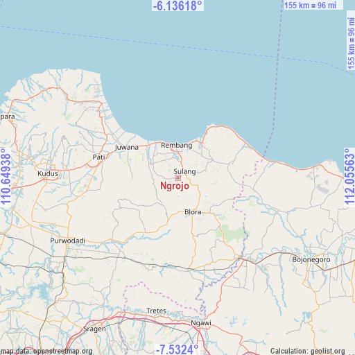
Ngrojo GPS coordinates[2]
6° 50' 5.28" South, 111° 21' 9" East
| Map corner | latitude | longitude |
|---|---|---|
| Upper-left | -6.13618°, | 110.64938° |
| Center: | -6.8348°, | 111.3525° |
| Lower-right: | -7.5324°, | 112.05563° |
| Map W x H: | 155.2×155.2 km | = 96.4×96.4mi |
| max Lat: | 5.88969° ⇑24.7% North |
| Ngrojo: | -6.8348° |
| min Lat: | ⇓75.3% South -10.934° |
| min Long | Ngrojo | max Long |
| 95.1345° | 111.3525° | 140.9419° |
| W 39%⇐ | ⇒61% E |
Elevation
Elevation of Ngrojo is 68 m = 223 ft, and this is 161.7 m = 531 ft below average elevation for this country.
| Max E: |
3185 m = 10449 ft | 57.9% |
| Avg. | 229.7 m = 754 ft | |
| Ngrojo | 68 m = 223 ft | |
Min E: |
-1 m = -3 ft | 42.1% |
See also: Indonesia elevation on elevation.city.
Geographical zone
Ngrojo is located in South Torrid zone (between Equator and Tropic of Capricorn). Distance of Equator is 760 km =472.2 mi to North.| Distance of | km | miles | from Ngrojo |
|---|---|---|---|
| Equator | 760 | 472.2 | to North |
| Tropic Capricorn | 1846 | 1147.1 | to South |
| Antarctic Circle | 6641.2 | 4126.6 | to South |
| South Pole | 9247.1 | 5745.9 | to South |


Nearby cities:
15 places around Ngrojo: (largest is in red/bold)
• Cabean
0.9 km =0.6 mi,  154°
154°
• Karangasem
2.2 km =1.4 mi, 145°
• Kemadu
3.9 km =2.4 mi,  58°
58°
• Krajan Tengah Sendangmulyo
3.9 km =2.4 mi,  238°
238°
• Lambangan Kulon
0.7 km =0.4 mi,  93°
93°
• Lambangan Wetan
1.7 km =1.1 mi,  66°
66°
• Ngaglik
1.7 km =1.1 mi,  109°
109°
• Pasedan Dua
4.5 km =2.8 mi,  134°
134°
• Pelemsari
4.5 km =2.8 mi,  274°
274°
• Pinggan
1.8 km =1.1 mi,  209°
209°
• Pondokrejo Wetan
3.1 km =1.9 mi, 266°
• Ponjen
3.8 km =2.4 mi, 94°
• Sulang Tengah
4.4 km =2.7 mi,  44°
44°
• Tanjung Utara
2.8 km =1.7 mi, 44°
• Tegalsari
4.1 km =2.5 mi,  47°
47°
Sources, notices
• [Note1] Compared only with cities in Indonesia existing in our database
• [Src1] Map data: © OpenStreetMap contributors (CC-BY-SA)
• [Src2] Other city data from geonames.org with taken over terms of usage.
• [Src3] Geographical zone / Annual Mean Temperature by Robert A. Rohde @ Wikipedia
