Pasedan Dua geodata
Pasedan Dua (Central Java) is a seat of a fourth-order administrative division; located in Indonesia in Asia/Jakarta (GMT+7) time zone. In our database, there are 407 cities with bigger population. Compared to other cities in Indonesia, 74.5% of cities are located further ↓South; 60.5% of cities are located further →East and 60% of cities have lower elevation than Pasedan Dua. Note1


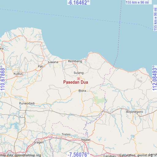
Pasedan Dua GPS coordinates[2]
6° 51' 47.52" South, 111° 22' 54.48" East
| Map corner | latitude | longitude |
|---|---|---|
| Upper-left | -6.16462°, | 110.67868° |
| Center: | -6.8632°, | 111.3818° |
| Lower-right: | -7.56076°, | 112.08493° |
| Map W x H: | 155.2×155.2 km | = 96.4×96.4mi |
| max Lat: | 5.88969° ⇑25.5% North |
| Pasedan Dua: | -6.8632° |
| min Lat: | ⇓74.5% South -10.934° |
| min Long | Pasedan Dua | max Long |
| 95.1345° | 111.3818° | 140.9419° |
| W 39.5%⇐ | ⇒60.5% E |
Elevation
Elevation of Pasedan Dua is 164 m = 538 ft, and this is 65.7 m = 216 ft below average elevation for this country.
| Max E: |
3185 m = 10449 ft | 40% |
| Avg. | 229.7 m = 754 ft | |
| Pasedan Dua | 164 m = 538 ft | |
Min E: |
-1 m = -3 ft | 60% |
See also: Indonesia elevation on elevation.city.
Geographical zone
Pasedan Dua is located in South Torrid zone (between Equator and Tropic of Capricorn). Distance of Equator is 763.1 km =474.2 mi to North.| Distance of | km | miles | from Pasedan Dua |
|---|---|---|---|
| Equator | 763.1 | 474.2 | to North |
| Tropic Capricorn | 1842.8 | 1145.1 | to South |
| Antarctic Circle | 6638.1 | 4124.7 | to South |
| South Pole | 9243.9 | 5743.9 | to South |


Nearby cities:
15 places around Pasedan Dua: (largest is in red/bold)
• Bulu
2.7 km =1.7 mi,  79°
79°
• Cabean
3.7 km =2.3 mi,  309°
309°
• Jukung
3.5 km =2.2 mi,  49°
49°
• Kadiwono
5.5 km =3.4 mi,  86°
86°
• Karangasem
2.4 km =1.5 mi,  303°
303°
• Kebon
5.2 km =3.2 mi, 85°
• Kemadu
5.2 km =3.2 mi,  0°
0°
• Lambangan Kulon
4 km =2.5 mi,  320°
320°
• Lambangan Wetan
4.2 km =2.6 mi,  336°
336°
• Ngaglik
3 km =1.9 mi,  327°
327°
• Ngrojo
4.5 km =2.8 mi, 314°
• Pinggan
4.4 km =2.7 mi,  291°
291°
• Ponjen
2.9 km =1.8 mi,  10°
10°
• Semanten
5.8 km =3.6 mi,  178°
178°
• Tanjung Utara
5.3 km =3.3 mi,  346°
346°
Sources, notices
• [Note1] Compared only with cities in Indonesia existing in our database
• [Src1] Map data: © OpenStreetMap contributors (CC-BY-SA)
• [Src2] Other city data from geonames.org with taken over terms of usage.
• [Src3] Geographical zone / Annual Mean Temperature by Robert A. Rohde @ Wikipedia
