Gaplokan geodata
Gaplokan (Central Java) is a seat of a fourth-order administrative division; located in Indonesia in Asia/Jakarta (GMT+7) time zone. In our database, there are 407 cities with bigger population. Compared to other cities in Indonesia, 73.1% of cities are located further ↓South; 62% of cities are located further →East and 60% of cities have lower elevation than Gaplokan. Note1


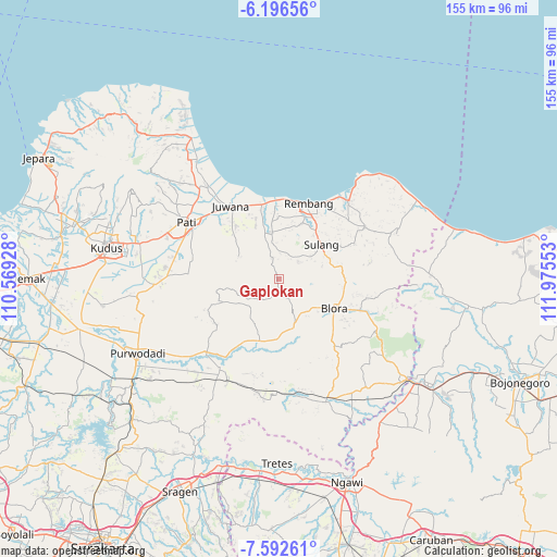
Gaplokan GPS coordinates[2]
6° 53' 42.36" South, 111° 16' 20.64" East
| Map corner | latitude | longitude |
|---|---|---|
| Upper-left | -6.19656°, | 110.56928° |
| Center: | -6.8951°, | 111.2724° |
| Lower-right: | -7.59261°, | 111.97553° |
| Map W x H: | 155.2×155.2 km | = 96.4×96.4mi |
| max Lat: | 5.88969° ⇑26.9% North |
| Gaplokan: | -6.8951° |
| min Lat: | ⇓73.1% South -10.934° |
| min Long | Gaplokan | max Long |
| 95.1345° | 111.2724° | 140.9419° |
| W 38%⇐ | ⇒62% E |
Elevation
Elevation of Gaplokan is 164 m = 538 ft, and this is 65.7 m = 216 ft below average elevation for this country.
| Max E: |
3185 m = 10449 ft | 40% |
| Avg. | 229.7 m = 754 ft | |
| Gaplokan | 164 m = 538 ft | |
Min E: |
-1 m = -3 ft | 60% |
See also: Indonesia elevation on elevation.city.
Geographical zone
Gaplokan is located in South Torrid zone (between Equator and Tropic of Capricorn). Distance of Equator is 766.7 km =476.4 mi to North.| Distance of | km | miles | from Gaplokan |
|---|---|---|---|
| Equator | 766.7 | 476.4 | to North |
| Tropic Capricorn | 1839.3 | 1142.9 | to South |
| Antarctic Circle | 6634.5 | 4122.5 | to South |
| South Pole | 9240.4 | 5741.7 | to South |


Nearby cities:
15 places around Gaplokan: (largest is in red/bold)
• Goge
5.6 km =3.5 mi,  359°
359°
• Japah
5.6 km =3.5 mi,  159°
159°
• Kalinanas
3.8 km =2.4 mi,  340°
340°
• Karangori
4.4 km =2.7 mi, 156°
• Kedungbacin
6 km =3.7 mi,  301°
301°
• Koro
7 km =4.3 mi, 296°
• Mlatirejo
6.5 km =4 mi,  33°
33°
• Ngapus
6.1 km =3.8 mi,  210°
210°
• Ngiyono
4.4 km =2.7 mi,  96°
96°
• Padaan
6.2 km =3.9 mi,  150°
150°
• Pandansili
6.8 km =4.2 mi,  17°
17°
• Pulo
4.9 km =3 mi,  196°
196°
• Ronggo
6.2 km =3.9 mi, 343°
• Sumberejo
4.8 km =3 mi,  116°
116°
• Tlogowungu
4.2 km =2.6 mi,  170°
170°
Sources, notices
• [Note1] Compared only with cities in Indonesia existing in our database
• [Src1] Map data: © OpenStreetMap contributors (CC-BY-SA)
• [Src2] Other city data from geonames.org with taken over terms of usage.
• [Src3] Geographical zone / Annual Mean Temperature by Robert A. Rohde @ Wikipedia
