Japah geodata
Japah (Central Java) is a seat of a third-order administrative division; located in Indonesia in Asia/Jakarta (GMT+7) time zone. In our database, there are 407 cities with bigger population. Compared to other cities in Indonesia, 70% of cities are located further ↓South; 61.9% of cities are located further →East and 51.1% of cities have higher elevation than Japah. Note1


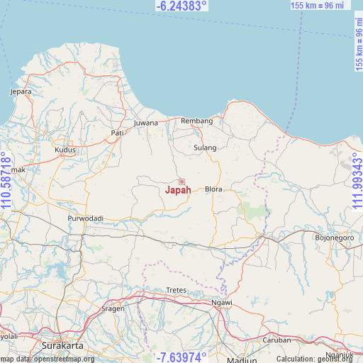
Japah GPS coordinates[2]
6° 56' 32.28" South, 111° 17' 25.08" East
| Map corner | latitude | longitude |
|---|---|---|
| Upper-left | -6.24383°, | 110.58718° |
| Center: | -6.9423°, | 111.2903° |
| Lower-right: | -7.63974°, | 111.99343° |
| Map W x H: | 155.2×155.2 km | = 96.4×96.4mi |
| max Lat: | 5.88969° ⇑30% North |
| Japah: | -6.9423° |
| min Lat: | ⇓70% South -10.934° |
| min Long | Japah | max Long |
| 95.1345° | 111.2903° | 140.9419° |
| W 38.1%⇐ | ⇒61.9% E |
Elevation
Elevation of Japah is 98 m = 322 ft, and this is 131.7 m = 432 ft below average elevation for this country.
| Max E: |
3185 m = 10449 ft | 51.1% |
| Avg. | 229.7 m = 754 ft | |
| Japah | 98 m = 322 ft | |
Min E: |
-1 m = -3 ft | 48.9% |
See also: Indonesia elevation on elevation.city.
Geographical zone
Japah is located in South Torrid zone (between Equator and Tropic of Capricorn). Distance of Equator is 771.9 km =479.6 mi to North.| Distance of | km | miles | from Japah |
|---|---|---|---|
| Equator | 771.9 | 479.6 | to North |
| Tropic Capricorn | 1834 | 1139.6 | to South |
| Antarctic Circle | 6629.3 | 4119.3 | to South |
| South Pole | 9235.2 | 5738.5 | to South |


Nearby cities:
15 places around Japah: (largest is in red/bold)
• Beganjing
1.8 km =1.1 mi,  154°
154°
• Bocowanti
4.6 km =2.9 mi,  133°
133°
• Bogorejo
4.1 km =2.5 mi,  83°
83°
• Karangori
1.2 km =0.7 mi,  348°
348°
• Krocok
3.8 km =2.4 mi,  205°
205°
• Ngrambitan
2.9 km =1.8 mi,  141°
141°
• Padaan
1 km =0.6 mi,  97°
97°
• Pengkolrejo
4.3 km =2.7 mi,  118°
118°
• Pulo
3.4 km =2.1 mi,  278°
278°
• Sumberejo
3.9 km =2.4 mi,  36°
36°
• Suren
3.7 km =2.3 mi,  157°
157°
• Tengger
4.9 km =3 mi,  170°
170°
• Tlogowungu
1.7 km =1.1 mi,  310°
310°
• Wantil
5 km =3.1 mi, 134°
• Wotbakah
3 km =1.9 mi,  93°
93°
Sources, notices
• [Note1] Compared only with cities in Indonesia existing in our database
• [Src1] Map data: © OpenStreetMap contributors (CC-BY-SA)
• [Src2] Other city data from geonames.org with taken over terms of usage.
• [Src3] Geographical zone / Annual Mean Temperature by Robert A. Rohde @ Wikipedia
