Telgawah geodata
Telgawah (Central Java) is a seat of a fourth-order administrative division; located in Indonesia in Asia/Jakarta (GMT+7) time zone. In our database, there are 407 cities with bigger population. Compared to other cities in Indonesia, 75.8% of cities are located further ↓South; 59% of cities are located further →East and 56.8% of cities have higher elevation than Telgawah. Note1


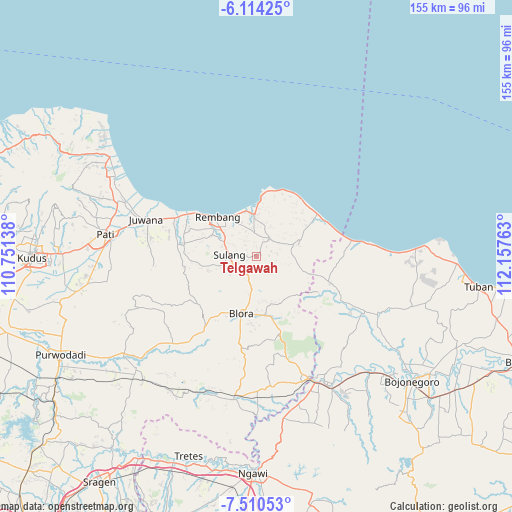
Telgawah GPS coordinates[2]
6° 48' 46.44" South, 111° 27' 16.2" East
| Map corner | latitude | longitude |
|---|---|---|
| Upper-left | -6.11425°, | 110.75138° |
| Center: | -6.8129°, | 111.4545° |
| Lower-right: | -7.51053°, | 112.15763° |
| Map W x H: | 155.3×155.3 km | = 96.5×96.5mi |
| max Lat: | 5.88969° ⇑24.2% North |
| Telgawah: | -6.8129° |
| min Lat: | ⇓75.8% South -10.934° |
| min Long | Telgawah | max Long |
| 95.1345° | 111.4545° | 140.9419° |
| W 41%⇐ | ⇒59% E |
Elevation
Elevation of Telgawah is 74 m = 243 ft, and this is 155.7 m = 511 ft below average elevation for this country.
| Max E: |
3185 m = 10449 ft | 56.8% |
| Avg. | 229.7 m = 754 ft | |
| Telgawah | 74 m = 243 ft | |
Min E: |
-1 m = -3 ft | 43.2% |
See also: Indonesia elevation on elevation.city.
Geographical zone
Telgawah is located in South Torrid zone (between Equator and Tropic of Capricorn). Distance of Equator is 757.5 km =470.7 mi to North.| Distance of | km | miles | from Telgawah |
|---|---|---|---|
| Equator | 757.5 | 470.7 | to North |
| Tropic Capricorn | 1848.4 | 1148.5 | to South |
| Antarctic Circle | 6643.7 | 4128.2 | to South |
| South Pole | 9249.5 | 5747.4 | to South |


Nearby cities:
15 places around Telgawah: (largest is in red/bold)
• Banyuurip
3.9 km =2.4 mi,  266°
266°
• Demaan
2.7 km =1.7 mi,  283°
283°
• Gunem
1.4 km =0.9 mi,  61°
61°
• Karanganyar
3.5 km =2.2 mi,  305°
305°
• Kulutan
1.9 km =1.2 mi,  37°
37°
• Ngemplakrejo Lor
2.7 km =1.7 mi,  0°
0°
• Panohan
1.9 km =1.2 mi,  263°
263°
• Pragen Selatan
2.8 km =1.7 mi,  24°
24°
• Rukem
4.5 km =2.8 mi, 284°
• Sambong
4.1 km =2.5 mi,  292°
292°
• Sendangmulyo
0.9 km =0.6 mi, 261°
• Sidomulyo
1 km =0.6 mi, 40°
• Tempaling
4.2 km =2.6 mi,  349°
349°
• Tempel
3.1 km =1.9 mi, 347°
• Trembes
4 km =2.5 mi,  85°
85°
Sources, notices
• [Note1] Compared only with cities in Indonesia existing in our database
• [Src1] Map data: © OpenStreetMap contributors (CC-BY-SA)
• [Src2] Other city data from geonames.org with taken over terms of usage.
• [Src3] Geographical zone / Annual Mean Temperature by Robert A. Rohde @ Wikipedia
